Search Results
Thalia Dondero Political Papers
Identifier
Abstract
The Thalia Dondero Political Papers (1934-2003), contain correspondence, pamphlets and reports used by Dondero to conduct official business, as well as information on county and city budgets, social and health services, liquor and gaming, planning, public works, environmental impact reports and a large section on water management. Dondero served as a Clark County Commissioner for twenty years and engaged in numerous other civic and political activities. The bulk of the materials are derived from Dondero's last four years in office, 1990-1994, but a few items from Dondero's earlier career are included.
Archival Collection
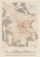
Map and basin profiles showing thickness of valley-fill deposits, Las Vegas Valley, Nevada, 1981 (color variation)
Date
Description
Image
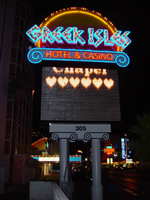
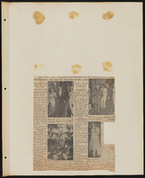
Photographs of Greek Isles signs, Las Vegas (Nev.), 2002
Date
Archival Collection
Description
Site address: 305 Convention Center Dr
Sign owner: Mark IV Realty
Sign details: The property which is at the eastern end of Convention Center Dr., is one tower at the east end of the property, and is attached to a low-rise structure which reaches westward along the east side of Convention Center drive. Various signs adorn the facade of the Greek Isles including a small pylon sign, a porte- cochere and two wall/logo signs. The stucco surface of the front of the building is painted with images of rustic Mediterranean cottages, as well as the rising or setting sun image seen on the pylon as well.
Sign condition: Structure 5 Surface 5 Lighting 5 Notes: The signage for the Greek Isles is essentially brand new, with exception to the porte-cochere. The Porte cochere was left over from the previous establishment with a bit of standard upkeep.
Sign form: Pylon; Fascia; Porte-cochère
Sign-specific description: At the east end of Convention center Blvd The Greek Isles casino resides at the old site of establishments such as The Paddlewheel, and The Debbie Reynolds Hotel Casino. The signage consists a pylon sign, a porte- cochere and two wall signs. Located on the south side of the street, the signage is located in relatively small span of space along the north face of the establishment. At the western most end of the property, a section of the low rise structure radiuses outward creating a giant white, convex stucco canvass. A golden sunset has been painted on the entire surface of this rounded wall. A bright white round section represents it with the color blending from an intense yellow into a burnt orange on the top edge of the building. At the top of the wall along the surface, "Greek Isles is spelled in shallow blue channel letters, with each letter set upon a white cabinet which mimics the shape of the font. Incandescent bulbs fill each channel letter, surrounded by a border of blue neon. The text is very angular, also mimicking ancient Greek text and the text utilized in Caesar's Palace. Just below the text on the surface of the wall. A wall sign in the shape of a rectangle with scrolls on the either sides. The resultant effect is a two-dimension representation of an Ionic top of a column. The outer edge of the sign including the spiraling scrolls on either side is created with a narrow blue channel. Tubes of blue neon line the interior of this channel. The open rectangular space left in the banner of the sign reads "Hotel &Casino," in red channel letters, lined with red neon on the interiors. Further east on the surface of the building, the white stucco is treated with a mural of broken tile overhangs and open shutters. Column, and corbels are other elements represented in the mural of a Greek village. Another sign is located on the wall between the western most sign and the central Porte cochere. This sign is two parts. Pair of concrete columns support a cabinet, crafted in the same fashion as the secondary portion of the previously mentioned sign. The details of the scroll are created by gold raceways lined with incandescent bulbs. Painted in red , all capital, letters, the text "Restaurant &Lounge Show," lies horizontally across the white surface. Neon is crafted over the tops of the letters. Sitting on top of the cabinet is another set of channel letters. The shallow blue letters are filled with incandescent bulbs. The shadowing cabinet, behind the letters is painted gold. Blue neon borders each one of the letters. On either side of the text, three slightly arched rods angle out of the body of the faux scrolled cabinet. The rods are lined on the surface with one single tube of blue neon. A pair of gold, polished, doors lie underneath the sign between the columns. The main entrance of the building is underneath the porte-cochere, continuing east along the property. The surface of the awning is illuminated with lengthy backlit cabinets, lined on the top and the bottom with gold raceways lined with incandescent bulbs. Blue tubes of neon line the top and the bottom edges of the surface of the cabinet. The underside of the awning is divided in clear plastic covered recessed cubes, forming a grid over the surface. The interiors of the cubes are mirrored, and sloped to a point in the negative shape of a pyramid. The centers are adorned with incandescent bulbs. The borders that periodically broken up with polished, reflective panels of a bronze hue. The property continues east still, until a north/south drive separates the building from the pylon sign for the establishment. A pair of white painted steel poles are capped with a white cabinet, sculpted itself to add elements to the poles themselves. The left and right bottom edges of the cabinet are crafted to look lime the scrolled column capital, represented in the two logo wall signs on the east surface. The scrolls are created with blue paint, n the white surface, as well as the address painted in the center. The combination of the sculpted cabinet and supporting poles create a solid base for a giant black cabinet which housed a color LED message center. Atop the cabinet, another horizontal cabinet sits wider in length than the LED cabinet. The cabinet is crafted like the two wall signs as well, with bulbous radius ends, adorned on the surface and edges with the channel raceways creating the scroll shape. This channel is lined with blue neon. All capital, red channel letters, filled with red neon, reads "Hotel & Casino." A top this cabinet another sculpted cabinet hold the main logo text of the sign. The sign is crafted as a half circle, creating a cabinet with the entire outer edge being a single radius. The surface of the sign is painted in the same fashion the sunset mural on the east end of the building. The sign starts as a dark orange at the bottom and fades to a yellow at the top. The edge of the radius is interrupted by the main text. "Greek Isles" is spelled in the same fashion as all the other signs. The mimicking backing cabinets for the letters are painted white as well. The outer edge is also lined with gold polished raceways , and incandescent bulbs. The width of the sign from the LED cabinet on up is painted black
Sign - type of display: Neon; Incandescent
Sign - media: Steel
Sign - non-neon treatments: Graphics; Paint
Sign animation: none
Sign environment: The Greek Isles is on the unique street line of Convention Center drive. To the east there is a nightclub, a chain motel, The Las Vegas Hilton, and the transplanted Riviera pylon. To the west, on that side of the street, is a bank complex and the Casino Royal. Across the street the vast expanse of the Hilton Convention Centers parking lot, makes the Greek Isles seem much larger for it's relatively small set of signage.
Sign manufacturer: YESCO
Sign - date of installation: 2000
Sign - date of redesign/move: The Greek Isles signage is the same since its initial installation, but replaces other vestiges of the previous properties, most recently the Debbie Reynolds Hotel and Casino.
Sign - thematic influences: The theme of the property is quite evident in its name as well as in its facade. The exterior is made to appear with elements of a rustic Greek village utilizing a white stucco finish treated with mural designs of wooden shutters and other village amenities. On western end of the property, the large round, surface of the wall is treated with graphic paint representative to a rising or setting sun. This element also adds to the apparent ambiance of the serene village. The text for the property is crafted in the generalized angular style of the ancient Greek text, not that much dissimilar to the Caesar's Palace logo text. In fact they are almost identical in fashion.
Surveyor: Joshua Cannaday
Survey - date completed: 2002
Sign keywords: Pylon; Fascia; Porte-cochère; Neon; Incandescent; Steel; Graphics; Paint
Mixed Content
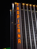
Photographs of Tropicana signs, Las Vegas (Nev.), 2002
Date
Archival Collection
Description
Photos show Tropicana signs at night. Two surveys were conducted to gather information about this sign. One was conducted in 2002 and one was conducted in 2017. PDFs are available for both surveys. See the 2017 survey PDF for additional information that is not included in the object description.
Site name: Tropicana Hotel and Casino (Las Vegas, Nev.)
Site address: 3801 S Las Vegas Blvd
Sign owner: Aztar
Sign details: The southeast corner of Las Vegas Blvd and Tropicana Boulevard belongs to the Tropicana Hotel Casino. The Tropicana is composed of two high-rise towers, the low-rise wings of rooms, and the casino itself. One tower faces southwest/northeast, while the other tower, further east on the property faces southeast/northwest. The expanse of the corner, near the street is an open concrete pedestrian plaza, with rising planters, a large functioning waterfall, also surrounded by foliage, and various vendors. The porte-cochere connects the plaza to the hotel, with the connecting bridge to the Excalibur, residing on top.
Sign condition: Structure 5 Surface 5 Lighting 5
Sign form: Pylon; Fascia
Sign-specific description: On the north and south faces of the porte-cochere roof line, on a pediment between the sloping blue roof and a row of brass fixtures, large channel letters in the faceted Tropicana font, horizontally spell "Tropicana." The exteriors are painted black wit a blue reflective finishing the interiors. They are filled with blue neon. The ceiling of the porte-cochere holds two distinct features to its credit. The north half is adorned with a glass domed hole through the roof. The interior thickness and recessed lip are covered in a polished metallic surface. Seashells adorn the edge where the lip meets the ceiling as well as on the face of the ledge as well. Teal, red and gold organic lines are floating across the surface in paint. The south half of the porte-cochere is covered with six recessed rectangular areas. Within the giant coffering a field of polished metal squares form a tiled field bordered with incandescent bulbs. In each of the corner intersections a sculpted glass cover, hold a single incandescent bulbs. Each field holds forty or so of these bulbs and their coverings. Two identical pylons flank the courtyard. One of them is on the south side of Tropicana avenue facing east /west, while the other faces north/south on the east side of the street. The pylon is essentially a giant double-sided rectangle with a top section that angles back into space on either side to meet at a peak. The result is a small roof like peak at the top of the sign supporting text on its face. The text however is standing up horizontally at a 90-degree angle. Besides the text logo at the top, the sign possesses an internally lit message cabinet on the bottom of the face, a small LED message center, and another backlit cabinet with a color advertisement for Follies Berger. The message center at the bottom is white plastic with vinyl lettering. The small message center is flanked by three steel poles, the height of the sign and finished to look like bamboo. The horizontal line created by the top edge of the sign is also lined with this false bamboo. The channel lettering at the top are polished metallic, shallow channel letters, which extend in depth all the way back to the face of the roof like form. The faces are filled with incandescent bulbs and bordered in neon. The sides of the sign are treated with a vertical bull nose like shape which runs vertically up the width of the sign. It is pointed wit ha triangular shape on both ends. The shape begins flush with the triangular peak of the signs profile and ends with its point approximately halfway down the height of the bottom message center. The bull nose is faceted with three faces. At the triangular tips, the three faces appear to make the space retain a jewel like shape. The middle face is laden with incandescent bulbs. The rest of the width of the sign is also finished in polished gold metal. The remaining open space on the faces of the cabinet, as well as exposed pieces of the cabinet, are painted a teal color. A border on incandescent bulbs runs around the entire face of the signage. The only signage present on the towers , is the on the first tower, closest to the corner. Running vertically down the west side of the southwest face of the tower, giant metallic channel letters spell "Tropicana" and are lined on the interiors with a double row of neon. Along the western end of the tower, three, double rows of incandescent bulbs run the entire height of the building. These animate, chasing each other down, simulating a waterfall.
Sign - type of display: Neon; Incandescent; Backlit; LED
Sign - media: Steel; Plastic
Sign - non-neon treatments: Graphics; Paint
Sign animation: Chasing, oscillating
Notes: Pylons: The incandescent bulbs inside the channel letters for the logo oscillate, as well as on the vertical width of the pylon. The raceways around the backlit screen chase each other, but it is a double row of incandescent bulbs that chase in opposite directions to each other. Building: The giant raceways of incandescent bulbs on the northwest corner of the Tropicana's front tower, chase each other from top to bottom, representing a waterfall.
Sign environment: The Tropicana belongs to one of the four major properties which comprise the intersection of Tropicana Ave. and Las Vegas Blvd The corner is occupied by a plaza and pedestrian element that is also seen in the other neighbors in the intersection as well. The towers loom over the plaza, as is accented by kiosks for patron promotions, and other services such as refreshments. The property is a good example of a property which has adapted over the years to fit and compete with the rapid evolution of Las Vegas.
Sign manufacturer: Original fascia design ( letters on building are what remain after remodel) by Heath and Company. Pylons: by YESCO
Sign designer: Original prismatic design was submitted by AD-Art's Jack DuBois ,but produced by Raul Rodriguez for heath and Company.
Sign - date of installation: 1978
Sign - date of redesign/move: The original facade was remodeled, which altered the exterior of the porte- cochere, but the letters remain.
Sign - thematic influences: The theme surrounding the Tropicana is that of the island paradise. References to the theming, that are evident on the exterior, are the shape and style of the text utilized in the various signage as well as those shapes being carried over into the designs other architectural elements. The blue incandescent bulbs that chase each other down the face of the building obviously reference a waterfall. Juxtaposed to the aesthetic, actual water elements have been incorporated into the front facade also. The angular design of the text is reminiscent of prism like faceted fonts is reminiscent many aspects dealing with Las Vegas, but fit more into the theme of the property than Vegas. The prismatic design is also incorporated into the design of the actual pylon also. The edges of the vertical length of the pylon are faceted and the triangular end seen on the fonts can be found elsewhere on the pylon. Not only is this shape evident with the pylon but on the fascia of the neighboring facade. The peaked rooflines of the village like facade also mirror this shape, being accented by the incandescent bulbs that line the edges. The text are reminiscent of something tropical, the shape somehow represents something rustic and wooden, even a tiki-like flavor.
Surveyor: Joshua Cannaday
Survey - date completed: 2002
Sign keywords: Chasing; Oscillating; Pylon; Fascia; Neon; Incandescent; Backlit; Steel; Plastic; Graphics; Paint; LED
Mixed Content
Descriptions of Native American reservations in Nevada, and Bureau of Indian Affairs requests for transfer of excess property: correspondence
Date
Archival Collection
Description
Correspondence between Joseph Zuni, Nevada Indian Agency, and attorney Thomas L. Leen describing the Las Vegas Paiute Colony and "allotted" vs. "communal" land. Western Nevada Indian Agency description of land acquisition for the Las Vegas Tribe of Paiute Indians. Memorandum to the Commissioner of Indian Affairs from the Chief, Division of Property and Supply Management, on the subject of real property acquisition "by the Bureau for use by Indian Tribes or groups." Letter from Commissioner Thomas M. Thawley to Assistant Secretary of the Interior Richard S. Bodman about requests from the Bureau of Indian Affairs for transfer of excess real property. Letter from Assistant Director Paul H. O'Neill to Commissioner Thomas H. Thawley "concerning the use of excess real property for various Indian programs." Letter from Thomas M. Thawley to Commissioner Louis R. Bruce about pending requests to the General Services Administration (GSA) for the transfer of excess real property. Transfer requests from Bureau of Indian Affairs with descriptions of property requested and proposed use. Letter from Assistant Director Paul H. O'Neill to Thomas M. Thawley about pending excess real property transfer requests. Correspondence between Teaching Assistant Elizabeth Warren and the Nevada Indian Agency asking about the history of reservations in Nevada.
Text
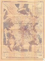
Map and basin profiles showing thickness of valley-fill deposits, Las Vegas Valley, Nevada, 1981
Date
Description
Image