Skip to main content
Main navigation
Finding Aids
Digital Projects
African American Experience in Las Vegas
Charles Saladino Landscape Architecture Collection
Culinary Union Photograph Collection
Dino at the Sands
Dreaming the Skyline
Entertainment
Historic Landscape of Nevada
Hoover Dam
Jamey Stillings
Menus: The Art of Dining
Nevada Test Site Oral History Project
Newspapers
Oral Histories Collection
Photograph Collections
Rebel Yell Newspaper
Showgirls
Southern Nevada: The Boomtown Years 1900-1925
Southern Nevada History in Maps
Southern Nevada Jewish Heritage Project
UNLV CSUN Records
Union Pacific Railroad Water Documents
Walking Box Ranch Collection
Welcome Home Howard
About
Request Images
Help
Provide Feedback
Special Collections Home
Search the Special Collections and Archives Portal
Search
Search
Breadcrumb
Special Collections and Archives Portal
All Digital Objects
Title
Digital Identifier
Items per page
30
60
90
Aerial photograph of Wahweap Boat Rentals on Lake Powell in Utah: digital photograph
Image
View
Aerial photograph of Wahweap Marina on Lake Powell in Arizona: digital photograph
Image
View
Aerial photograph of Lake Powell and Wahweap Bay, looking northwest in Arizona: digital photograph
Image
View
Aerial photograph of Glen Canyon Dam from downstream, looking northeast in Arizona: digital photograph
Image
View
Aerial photograph of Lake Powell at sunset, looking west towards the Glen Canyon Dam in Arizona: digital photograph
Image
View
Aerial photograph of Lake Powell's Antelope Point, looking east-northeast in Arizona: digital photograph
Image
View
Aerial photograph from above Lake Powell's Padre Bay, looking southeast towards Padre Butte in Utah: digital photograph
Image
View
Aerial photograph of lands surrounding Lake Powell's Gunsight Bay in Utah: digital photograph
Image
View
Aerial photograph of lands and mountains along the Green River near Labyrinth Bay in Utah: digital photograph
Image
View
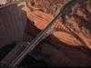
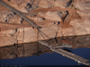
Aerial photograph of the Highway 89 bridge at Glen Canyon Dam in Arizona: digital photograph
Image
View
Aerial photograph of the Highway 89 bridge at Glen Canyon Dam in Arizona: digital photograph
Image
View
Aerial photograph of Glen Canyon Dam in Arizona: digital photograph
Image
View
Aerial photograph of Glen Canyon Dam, looking northeast in Arizona: digital photograph
Image
View
Aerial photograph of Glen Canyon Dam, looking northeast in Arizona: digital photograph
Image
View
Aerial photograph of Horseshoe Bend in Arizona: digital photograph
Image
View
Aerial photograph of Horseshoe Bend in Arizona: digital photograph
Image
View
Aerial photograph of Glen Canyon Dam from below the dam, looking north in Arizona: digital photograph
Image
View
Aerial photograph of Wahweap Marina at Lake Powell in Arizona: digital photograph
Image
View
Aerial photograph of a landlocked Antelope Point launch ramp at Lake Powell in Arizona: digital photograph
Image
View
Aerial photograph showing an entrance dock displaced and rigged for use during low water levels at the Antelope Point Marina at Lake Powell in Arizona: digital photograph
Image
View
Aerial photograph of an entrance dock and houseboats at the Antelope Point Marina at Lake Powell in Arizona: digital photograph
Image
View
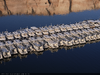
Aerial photograph of houseboats at the Antelope Point Marina at Lake Powell in Arizona: digital photograph
Image
View
Aerial photograph of houseboats at the Antelope Point Marina at Lake Powell in Arizona: digital photograph
Image
View
Aerial photograph of houseboats at the Antelope Point Marina at Lake Powell in Arizona: digital photograph
Image
View
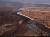
Aerial photograph of low water levels at Lake Powell, looking south from Utah into Arizona: digital photograph
Image
View
Aerial photograph of land sculpted by receding water levels at Lake Powell in Utah: digital photograph
Image
View
Aerial photograph of land sculpted by receding water levels at Lake Powell in Utah: digital photograph
Image
View
Aerial photograph of shoreline sculpted by receding water levels in Lake Powell's Gunsight Bay in Utah: digital photograph
Image
View
Aerial photograph of shoreline sculpted by receding water levels in Lake Powell's Gunsight Bay in Utah: digital photograph
Image
View
Aerial photograph of shoreline sculpted by receding water levels in Lake Powell's Gunsight Bay in Utah: digital photograph
Image
View
Pagination
First page
« First
Previous page
‹‹
…
Page
20
Page
21
Page
22
Page
23
Current page
24
Page
25
Page
26
Page
27
Page
28
…
Next page
››
Last page
Last »