Skip to main content
Main navigation
Finding Aids
Digital Projects
African American Experience in Las Vegas
Charles Saladino Landscape Architecture Collection
Culinary Union Photograph Collection
Dino at the Sands
Dreaming the Skyline
Entertainment
Historic Landscape of Nevada
Hoover Dam
Jamey Stillings
Menus: The Art of Dining
Nevada Test Site Oral History Project
Newspapers
Oral Histories Collection
Photograph Collections
Rebel Yell Newspaper
Showgirls
Southern Nevada: The Boomtown Years 1900-1925
Southern Nevada History in Maps
Southern Nevada Jewish Heritage Project
UNLV CSUN Records
Union Pacific Railroad Water Documents
Walking Box Ranch Collection
Welcome Home Howard
About
Request Images
Help
Provide Feedback
Special Collections Home
Search the Special Collections and Archives Portal
Search
Search
Breadcrumb
Special Collections and Archives Portal
Utah
Authority Link
GeoNames
Broader
United States
Feature
first-order administrative division
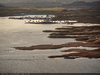
Aerial photograph of the Bullfrog Marina area of Lake Powell, looking north-northeast in Utah: digital photograph
Image
View
Aerial photograph of a boat near a landlocked Charles Hall Ferry launching pad on Lake Powell, looking south in Utah: digital photograph
Image
View
Aerial photograph of Bullfrog Marina on Lake Powell in Utah: digital photograph
Image
View
Aerial photograph of Bullfrog Marina on Lake Powell, looking north in Utah: digital photograph
Image
View
Aerial photograph of Bullfrog Marina on Lake Powell, looking northeast in Utah: digital photograph
Image
View
Aerial photograph of Bullfrog Marina on Lake Powell, looking west in Utah: digital photograph
Image
View
Aerial photograph of Bullfrog Marina on Lake Powell, looking north in Utah: digital photograph
Image
View
Aerial photograph of Bullfrog Marina on Lake Powell, looking west in Utah: digital photograph
Image
View
Aerial photograph of Halls Crossing Marina on Lake Powell, looking south in Utah: digital photograph
Image
View
Aerial photograph of a tributary to Lake Powell in Utah: digital photograph
Image
View
Aerial photograph of the San Juan River, looking northwest near Lake Powell in Utah: digital photograph
Image
View
Aerial photograph showing land sculpted by the receding water level at Lake Powell in Arizona: digital photograph
Image
View
Aerial photograph of Antelope Point Marina on Lake Powell, looking southwest in Arizona: digital photograph
Image
View
Aerial photograph of Lake Powell near Antelope Island in Arizona: digital photograph
Image
View
Aerial photograph showing the Wahweap Marina area from above Lake Powell, looking south in Arizona: digital photograph
Image
View
Aerial photograph of shoreline on Lake Powell in Utah: digital photograph
Image
View
Aerial photograph showing Glen Canyon Dam from above Lake Powell, looking south in Arizona: digital photograph
Image
View
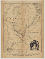
"Las Vegas & Tonopah Railroad - The Goldfield Route" map
Image
View
Pagination
First page
« First
Previous page
‹‹
…
Page
5
Page
6
Page
7
Page
8
Current page
9
Page
10
Page
11
Page
12
Page
13
Next page
››
Last page
Last »