Skip to main content
Main navigation
Finding Aids
Digital Projects
African American Experience in Las Vegas
Charles Saladino Landscape Architecture Collection
Culinary Union Photograph Collection
Dino at the Sands
Dreaming the Skyline
Entertainment
Historic Landscape of Nevada
Hoover Dam
Jamey Stillings
Menus: The Art of Dining
Nevada Test Site Oral History Project
Newspapers
Oral Histories Collection
Photograph Collections
Rebel Yell Newspaper
Showgirls
Southern Nevada: The Boomtown Years 1900-1925
Southern Nevada History in Maps
Southern Nevada Jewish Heritage Project
UNLV CSUN Records
Union Pacific Railroad Water Documents
Walking Box Ranch Collection
Welcome Home Howard
About
Request Images
Help
Provide Feedback
Special Collections Home
Search the Special Collections and Archives Portal
Search
Search
Breadcrumb
Special Collections and Archives Portal
North America--Colorado River Region
Aerial photograph of Stewarts Bay of Lake Mead, looking south as seen from the Nevada side: digital photograph
Image
View
Aerial photograph of desert along the Overton Arm of Lake Mead, looking east as seen from the Nevada side: digital photograph
Image
View
Aerial photograph of Overton Arm of Lake Mead, looking southeast as seen from the Nevada side: digital photograph
Image
View
Aerial photograph of Rotary Cove, looking southwest towards Lake Mead's Boulder Basin: digital photograph
Image
View
Aerial photograph of South Cove Marina looking southeast on the Arizona side of Lake Mead's Gregg Basin: digital photograph
Image
View
Aerial photograph of the shoreline on the Nevada side along Lake Mead's Gregg Basin: digital photograph
Image
View
Aerial photograph of silt mixing with still water in Lake Mead's Gregg Basin: digital photograph
Image
View
Aerial photograph of the Colorado River looking southwest as its silt mixes with still water in Lake Mead's Gregg Basin: digital photograph
Image
View
Aerial photograph of the Colorado River looking southwest as its silt mixes with still water in Lake Mead's Gregg Basin: digital photograph
Image
View
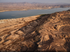
Aerial photograph of silt deposits along the Colorado River near where it enters Lake Mead: digital photograph
Image
View
Aerial photograph of the silt filled Colorado River looking southwest near where it enters Lake Mead: digital photograph
Image
View
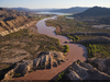
Aerial photograph of the Colorado River looking southwest near where it enters Lake Mead: digital photograph
Image
View
Aerial photograph of the Colorado River looking southwest near where it enters Lake Mead: digital photograph
Image
View
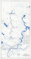
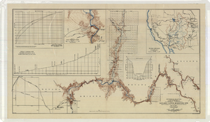
Map and operational diagram, lower Colorado River, Lees Ferry to Gulf of California, June 1973
Image
View
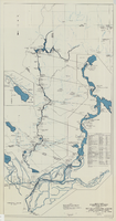
Map and operational diagram, lower Colorado River, Lees Ferry to Gulf of California, May 1957
Image
View
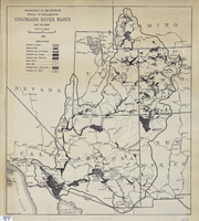
Map of Colorado River Basin, 1928
Image
View
Topographic map of the Boulder Canyon Reservoir site, 1930
Image
View
Pagination
First page
« First
Previous page
‹‹
…
Page
7
Page
8
Page
9
Page
10
Page
11
Page
12
Page
13
Page
14
Current page
15