Skip to main content
Main navigation
Finding Aids
Digital Projects
African American Experience in Las Vegas
Charles Saladino Landscape Architecture Collection
Culinary Union Photograph Collection
Dino at the Sands
Dreaming the Skyline
Entertainment
Historic Landscape of Nevada
Hoover Dam
Jamey Stillings
Menus: The Art of Dining
Nevada Test Site Oral History Project
Newspapers
Oral Histories Collection
Photograph Collections
Rebel Yell Newspaper
Showgirls
Southern Nevada: The Boomtown Years 1900-1925
Southern Nevada History in Maps
Southern Nevada Jewish Heritage Project
UNLV CSUN Records
Union Pacific Railroad Water Documents
Walking Box Ranch Collection
Welcome Home Howard
About
Request Images
Help
Provide Feedback
Special Collections Home
Search the Special Collections and Archives Portal
Search
Search
Breadcrumb
Special Collections and Archives Portal
Water consumption
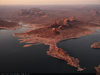
Aerial photograph of land sculpted by receding water levels at Lake Powell in Utah: digital photograph
Image
View
Aerial photograph of shoreline sculpted by receding water levels in Lake Powell's Gunsight Bay in Utah: digital photograph
Image
View
Aerial photograph of shoreline sculpted by receding water levels in Lake Powell's Gunsight Bay in Utah: digital photograph
Image
View
Aerial photograph of shoreline sculpted by receding water levels in Lake Powell's Gunsight Bay in Utah: digital photograph
Image
View
Aerial photograph of shoreline in Lake Powell's Gunsight Bay with a moored houseboat in Utah: digital photograph
Image
View
Aerial photograph of a boat in Lake Powell's Gunsight Bay in Utah: digital photograph
Image
View
Aerial photograph showing a houseboat moored along a Lake Powell shoreline in Utah: digital photograph
Image
View
Aerial photograph showing Padres Butte in Lake Powell, Utah: digital photograph
Image
View
Aerial photograph showing the West Canyon Creek portion of Lake Powell in Utah: digital photograph
Image
View
Aerial photograph from above Lake Powell, looking west towards Gunsight Butte in Utah: digital photograph
Image
View
Aerial photograph from above Lake Powell's Padre Bay, looking south towards Padres Butte and Face Canyon in Utah: digital photograph
Image
View
Aerial photograph of shoreline from above Lake Powell's Last Chance Bay in Utah: digital photograph
Image
View
Aerial photograph from above Lake Powell, looking south towards Mountain Sheep Canyon in Utah: digital photograph
Image
View
Aerial photograph of the Reflection Canyon section of Lake Powell in Utah: digital photograph
Image
View
Aerial photograph of Davis Gulch in the Escalante River section of Lake Powell in Utah: digital photograph
Image
View
Aerial photograph of a canyon wall along the Escalante River section of Lake Powell in Utah: digital photograph
Image
View
Aerial photograph of a recently fallen section of a canyon wall along the Escalante River section of Lake Powell in Utah: digital photograph
Image
View
Aerial photograph of a recently fallen section of a canyon wall along the Escalante River section of Lake Powell in Utah: digital photograph
Image
View
Pagination
First page
« First
Previous page
‹‹
…
Page
3
Page
4
Page
5
Page
6
Current page
7
Page
8
Page
9
Page
10
Page
11
…
Next page
››
Last page
Last »