Skip to main content
Main navigation
Finding Aids
Digital Projects
African American Experience in Las Vegas
Charles Saladino Landscape Architecture Collection
Culinary Union Photograph Collection
Dino at the Sands
Dreaming the Skyline
Entertainment
Historic Landscape of Nevada
Hoover Dam
Jamey Stillings
Menus: The Art of Dining
Nevada Test Site Oral History Project
Newspapers
Oral Histories Collection
Photograph Collections
Rebel Yell Newspaper
Showgirls
Southern Nevada: The Boomtown Years 1900-1925
Southern Nevada History in Maps
Southern Nevada Jewish Heritage Project
UNLV CSUN Records
Union Pacific Railroad Water Documents
Walking Box Ranch Collection
Welcome Home Howard
About
Request Images
Help
Provide Feedback
Special Collections Home
Search the Special Collections and Archives Portal
Search
Search
Breadcrumb
Special Collections and Archives Portal
Nye County
Authority Link
GeoNames
Broader
Nevada
United States
Feature
second-order administrative division
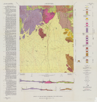
Geologic map of the Ammonia Tanks quadrangle, Nye County, Nevada, 1967
Image
View
Geology of the Jackass Flats quadrangle, Nye County, Nevada, 1964
Image
View
Geologic map of the Jangle Ridge quadrangle, Nye and Lincoln Counties, Nevada, 1965
Image
View
Geologic map of the Plutonium Valley quadrangle, Nye and Lincoln counties, Nevada, 1965
Image
View
Geologic map of the northeast quarter of the Bullfrog 15-minute quadrangle, Nye County, Nevada, 1990
Image
View
Surficial geologic map of the Specter Range NW quadrangle, Nye County, Nevada, 1989
Image
View
Geology of the Oak Spring Quadrangle, Nye County, Nevada, 1963
Image
View
Geologic map of the Tippipah Spring quadrangle, Nye County, Nevada, 1963
Image
View
Geologic map of the Topopah Spring quadrangle, Nye County, Nevada, 1970
Image
View
Geologic map of the Dead Horse Flat quadrangle, Nye County, Nevada, 1967
Image
View
Geologic map of the Lathrop Wells quadrangle, Nye County, Nevada, 1970
Image
View
Geologic map of the Paiute Ridge quadrangle, Nye and Lincoln Counties, Nevada, 1967
Image
View
Map of Las Vegas, Nevada and surrounding Bureau of Land Management areas to the west and north, 1994
Text
View
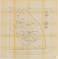
Map showing estimated average recharge to and discharge from ground-water reservoirs by basins, and hydraulic potential in Clark and Nye counties, Nevada, 1963
Image
View
Map of the Las Vegas ground-water basin, Clark, Nye, and Lincoln Counties, Nevada, 1965
Image
View
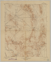
Map of Kawich Quadrangle, Nye County, Nevada, June 1908
Text
View
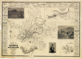
Map of Tonopah Mining District, Nye County, Nevada, 1902
Text
View
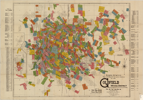
Map of U.S. patent and location surveys in the Goldfield Mining District, Esmeralda and Nye Counties, Nevada, 1907
Text
View
Pagination
First page
« First
Previous page
‹‹
Page
1
Page
2
Page
3
Page
4
Page
5
Current page
6
Page
7
Next page
››
Last page
Last »