Skip to main content
Main navigation
Finding Aids
Digital Projects
African American Experience in Las Vegas
Charles Saladino Landscape Architecture Collection
Culinary Union Photograph Collection
Dino at the Sands
Dreaming the Skyline
Entertainment
Historic Landscape of Nevada
Hoover Dam
Jamey Stillings
Menus: The Art of Dining
Nevada Test Site Oral History Project
Newspapers
Oral Histories Collection
Photograph Collections
Rebel Yell Newspaper
Showgirls
Southern Nevada: The Boomtown Years 1900-1925
Southern Nevada History in Maps
Southern Nevada Jewish Heritage Project
UNLV CSUN Records
Union Pacific Railroad Water Documents
Walking Box Ranch Collection
Welcome Home Howard
About
Request Images
Help
Provide Feedback
Special Collections Home
Search the Special Collections and Archives Portal
Search
Search
Breadcrumb
Special Collections and Archives Portal
Text
A resource consisting primarily of words for reading
Authority Sources
DCMI Type Vocabulary
Tonopah, Nevada mining map, March 1904
Text
View
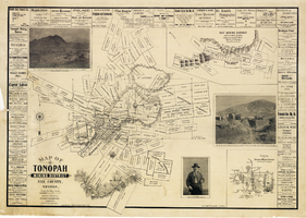
Map of Tonopah Mining District, Nye County, Nevada, 1902
Text
View
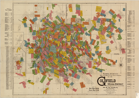
Map of U.S. patent and location surveys in the Goldfield Mining District, Esmeralda and Nye Counties, Nevada, 1907
Text
View
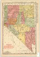
Map showing railroads in Nevada, 1911
Text
View
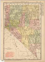
Map showing railroads in Nevada, 1904
Text
View
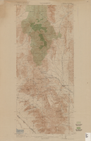
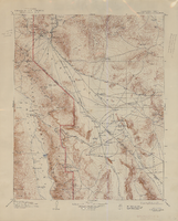
Topographic map of Goodsprings quadrangle, Nevada and California, 1919
Text
View
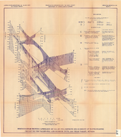
Fence diagram showing lithology of valley-fill deposits and summary of water-bearing properties for valley-fill and bedrock units, Las Vegas Valley, Nevada, 1981 (Open-file report 84-130)
Text
View
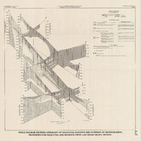
Fence diagram showing lithology of valley-fill deposits and summary of water-bearing properties for valley-fill and bedrock units, Las Vegas Valley, Nevada, 1981 (Water-supply paper 2320-A)
Text
View
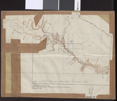
Topographic map of Arrow Canyon dam and reservoir site on the Muddy River, 1934
Text
View
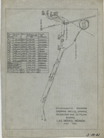
Diagrammatic drawing showing wells, springs, reservoir and settling basins, Las Vegas, Nevada, June 1942
Text
View
Topographic map of groundwater in the southeast quadrangle of Las Vegas, Nevada, 1980
Text
View
Topographic map of groundwater in the southwest quadrangle of Las Vegas, Nevada, 1985
Text
View
Topographic map of the Furnace Creek quadrangle, Nevada and California, 1947
Text
View
Topographic map of the Las Vegas Valley and surrounding northern and western mountain ranges, 1943
Text
View
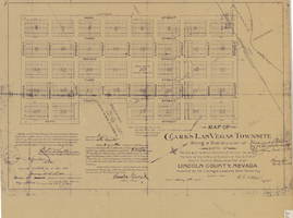
Map of Clark's Las Vegas Townsite, May 8, 1905
Text
View
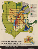
Map showing coordinated general plan for Las Vegas Valley, Planning Area A5, circa 1965-1968
Text
View
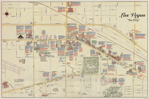
Maps of the Las Vegas Strip, downtown and metropolitan Las Vegas area, the Grand Canyon and southern Nevada, circa 1997
Text
View
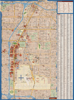
Maps of Las Vegas metropolitan area, Grand Canyon National Park and national parks near Las Vegas, Nevada, 2008
Text
View
Pagination
First page
« First
Previous page
‹‹
…
Page
2037
Page
2038
Page
2039
Page
2040
Current page
2041
Page
2042
Page
2043
Page
2044
Page
2045
…
Next page
››
Last page
Last »