Search Results

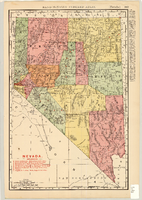
Map of Nevada Railroads, 1904
Date
1904
Description
Scale [ca. 1:1,710,720]. 1 in. equals 27 miles (W 120 --W 114 /N 42 --N 35 ) ; 1 map : col. 47 x 31 cm ; Relief shown by hachures ; Added title: Rand McNally's new business map of Nevada ; Shows range and township grid ; Shows railroads ; Color used to show boundaries of counties ; Originally published as pages 263 and 264 of Rand-McNally indexed atlas ; Additional copyright date: c1893 ;
Image