Search Results
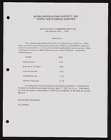
Alpha Kappa Alpha Sorority, Theta Theta Omega Chapter scholarship committee report
Date
Archival Collection
Description
From the Alpha Kappa Alpha Sorority, Incorporated, Theta Theta Omega Chapter Records (MS-01014) -- Chapter records file.
Text
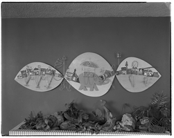
Metal wall art: photographic negative
Date
Archival Collection
Description
Photograph from the Dunes Hotel and Casino Records (MS-00328) -- General Records -- Correspondence file.
Image
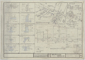
Regency Towers construction set: one-half scale reproductions of architectural, structural, mechanical, electrical, and plumbing drawings
Date
Archival Collection
Description
From the Homer Rissman Architectural Records (MS-00452) -- Regency Towers: Las Vegas, Nevada -- Project drawings file.
Image
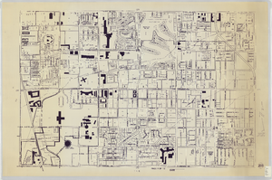
Zoning map of Las Vegas Metropolitan Area
Date
Description
13 maps ; 57 x 83 cm. Scale: [ca. 1:6,000]. 1 inch equals 500 feet. Las Vegas, Nev. : Clark County Zoning Dept. "Loney Sauceda, PC." Maps have been revised in different years; latest revision is 1988. "The preparation of this map financed in part through an urban planning grant from the Housing and Home Finance Agency." Page 1 is sheet 28, page 13 is sheet 42. Please note there is not a page 5, it is missing. Includes maps of Henderson.
Image
Sahara Hotel Phase IV architectural drawings
Date
Archival Collection
Description
Drawings from Martin Stern Architectural Records (MS-00382) -- Sahara Hotel and Casino: Las Vegas, Nevada -- Project drawings -- Phase 4: retail shops.
Image
Regency Towers: artist's rendering of an exterior building perspective
Date
Archival Collection
Description
Title sheet that lists an index of drawings. Drawing from Homer Rissman Architectural Records (MS-00452) -- Regency Towers: Las Vegas, Nevada -- Project drawings -- Artist's rendering of an exterior building perspective; Lobby and entertainment suite electrical drawings, sheets E1-E4 file.
Image
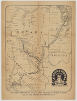
"Las Vegas & Tonopah Railroad - The Goldfield Route" map
Date
Description
Map showing "Las Vegas & Tonopah Railroad 'The Goldfield Route.'" On the back it lists a timetable, railroad employees and executives, and descriptions of districts and towns: Johnnie, Beatty, Rhyolite, Bonnie Clare, Goldfield, Tonopah, Manhattan, Round Mountain, and Hornsilver.
Image
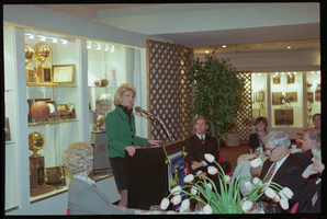
Steve and Elaine Wynn, Honorary Committee Group Shots: photographs
Date
Archival Collection
Description
Photographs from the University of Nevada, Las Vegas Creative Services Records (1990s) (PH-00388-03).
Image