Search Results
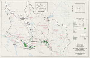
Map of Region 3 projects, Arizona-California-Nevada-New Mexico-Utah, September 1967
Date
1967-09
Description
25 x 39 cm. United States, Department of the Interior, Bureau of Reclamation. Relief shown pictorially. "Map no. X-300-738." "September 1967." Shows completed, under construction and proposed dams and reservoirs, canals, and aqueducts, power plants, pumping plants, substations, transmission lines, tunnels and siphons. Also shows non-Bureau of Reclamation dams, reservoirs, tunnels, pipelines and irrigated lands. Includes inset map of location of Region 3 and key map of drainage basins. Original Publisher: Interior.
Image
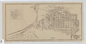
Cadastral map of Boulder City, Nevada, 1940
Date
1905-04-23
Description
A. M. S. Jan. 1940 in the lower left-hand corner. 1 map ; 61 x 30 cm. Cadastral map. "No. 40-1" in the lower right-hand corner. Shows block and lot numbers, buildings, water supply and sewage system, leased areas.
Image
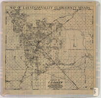
Map of Las Vegas Valley, Clark County, Nevada, October 1, 1940
Date
1940-10-01
Description
'Compiled by C.D. Baker, Civil Engineer, State Water Right Surveyor, Mineral Surveyor, Gen. Land Office, Las Vegas, Clark County, Nevada. Oct. 1, 1940.' Scale [ca. 1:48,000]. 1 in. to 4,000 ft. Cadastral map.
Image
Map showing areas of bedrock and valley fill, drainage boundary, areas of artesian flow, and precipitation stations in the Las Vegas Valley area, 1946
Date
1946
Description
At top of map: 'United Sates Department of Interior, Geological Survey, Water Resources Bulletin no. 5, plate 2.' 'State Engiener of Nevada.' Relief shown by contours and spot heights. Scale [ca. 1:126,720. 1 inch to approx. 2 miles]
Image

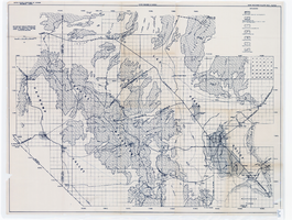
Map of Las Vegas Valley artesian basin, circa 1940
Date
1938 to 1942
Description
Scale [ca. 1:72,000. 1 in.=approx. 6,000 feet] (W 115°10´--W 115°/N 36°20´--N 36´). Shows wells, springs, boundary between valley fill and bedrock, and ground water district boundaries for Las Vegas Metropolitan Area and North Las Vegas. "Figure 1." Nevada. State Engineer
Image

Map of Las Vegas, Nevada and surrounding Bureau of Land Management areas to the west and north, 1994
Date
1994
Description
'BLM edition, 1994.' 'Surface management status; mineral management status.' '1:100,000-scale topographic map showing highways, roads and other manmade structures; water features; contours and elevations in meters with conversions to feet; BLM recreation sites.' 'Edited and published by the Bureau of Land Management. Base map prepared by the U.S. Geological Survey.' I53:11/4-2
Text
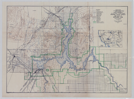
Topographic map of Boulder Canyon Project, Boulder Dam area, 1940
Date
1940
Description
Scale [ca. 1:221,760. 1 in. to approx. 3.5 miles] ; 1 map : col. ; 51 x 71 cm ; Relief shown by contours and spot heights ; Includes township and range grid ; "Map no. 40-40" ; Includes index map ; Shows power lines, triangulation stations, boundary monuments, roads, telephone lines, mines, bench marks, etc. ; U.S. Dept. of the Interior, Bureau of Reclamation
Image
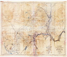
Topographic map of Boulder Canyon Project, Hoover Dam area, 1932
Date
1932
Description
Scale [ca. 1:221,760. 1 in. to approx. 3.5 miles] ; 1 map : col. ; 51 x 62 cm ; Relief shown by contours and spot heights ; "Prepared in Washington Office from compilation made in Las Vegas Office." ; "Map no. 24000." ; Includes township and range grid ; Shows power lines, triangulation stations, boundary monuments, roads, telephone lines, mines, bench marks, etc. ; Department of the Interior, Bureau of Reclamation.
Image
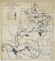
Map of Colorado River Basin, 1928
Date
1928
Description
52 x 46 cm. "Map no. 23000." Shows reservoir sites, irrigated areas, power plants, power sites, dam sites, national parks or monuments, and diversion from basin. Colorado River Basin/Department of the Interior, Bureau of Reclamation; John H. Pellen, chief draftsman. Original publisher: United States. Bureau of Reclamation.
Image

Map showing proposed annexation of Las Vegas Valley, Clark County, Nevada, January 1, 1929
Date
1929-01-01
Description
'Compiled by C. D. Baker, C.E., United States Mineral Surveyor, State Right Water Surveyor, Nevada. Las Vegas, Nev. January 1, 1929. Copyright applied for.' ; "Filed Dec. 10, 1936" and signed by Viola Burns, clerk, city of Las Vegas ; Hand-printed title at top of map: Proposed annexation to Las Vegas ; Map is stamped as Filed Dec 10, 1936 and signed by Las Vegas City Clerk Viola Burns. Library's copy has brown line hand-drawn around area to be annexed.
Image