Search the Special Collections and Archives Portal
Search Results

Slide of neon signs on Las Vegas Boulevard, Las Vegas, Nevada, circa 1980s
Date
1980 to 1986
Archival Collection
Description
Neon signs on the Las Vegas Strip at night, looking southwest from the Riviera and Circus Circus. Site Name: Las Vegas Boulevard
Image
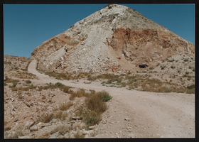
One of the original Arden Plaster Mines: photographic print
Date
1992
Archival Collection
Description
One of the original Arden plaster mines of 1909, located in the extreme southwest portion of the Las Vegas Valley. (photo by Don Walker, 1992)
Image
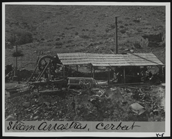
Steam arrastra at Cerbat, Arizona: photographic print
Date
1870 (year approximate) to 1979 (year approximate)
Archival Collection
Description
From the KLVX Steamboats on the Colorado Photograph Collection (PH-00156). Handwritten on verso: "Steam Arrastra Cerbat, CA 1870's." Writen on photo sleeve: "Steam arrastra, Ca. 1870's. Cerbat, Arizona Territory." Stamp on verso: "Mohave Museum of History and Arts. Classification: Mining, Negative No.: 416 , Negative:, Contact: ."
Image
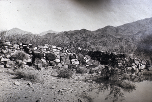
Slide of the Callville ruins, Callville, Nevada, circa 1930s
Date
1930 to 1939
Archival Collection
Description
A view of the Callville ruins at Lake Mead, Nevada. Callville is a former settlement of Clark County, Nevada. Abandoned in 1869, Callville was submerged under 400 feet (120 m) of water after the Colorado River was dammed to form Lake Mead. Callville Bay recreation area is located at the site. Located 350 miles (560 km) from Salt Lake City, Calville was situated on the west bank of the Colorado River, in what was at the time Pah-Ute County, Arizona Territory. The main road to the settlement was along the Virgin River close to St. Thomas, Nevada before heading over hills to the west. A road connected Callville with the main highway at Las Vegas. Callville was established in December 2, 1864 by Anson Call, Dr. James M. Whitmore, A. M. Cannon, Jacob Hamblin and son. It was at the time the southernmost outpost of Mormon settlement. Callville was one of seven Mormon settlements on or near the Muddy River, the others being St. Thomas, Saint Joseph, Overton, West Point, Mill Point later Simonsville and Rioville on the Colorado River above its confluence with the Virgin River. Callville became the county seat of Pah-Ute County, Arizona Territory, in December 1865, before the seat was moved on October 1, 1867 to St. Thomas.
Image
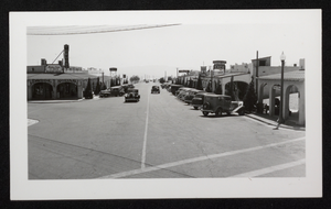
Photograph of downtown Boulder City, Nevada, circa 1931-late 1930s
Date
1931 to 1939
Archival Collection
Description
View of downtown Boulder City, probably taken from the intersection of Nevada Highway and Arizona Street, looking southwest, showing the Green Hut Cafe (512 Nevada Highway), the Nava-Hopi Indian Store, Delmar's (Boulder City) Drug Store, the Reservation Grill.
Image
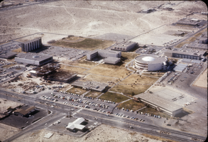
Slide of an aerial view of campus, University of Nevada, Las Vegas, circa 1971
Date
1971 to 1972
Archival Collection
Description
Partial aerial view, looking southwest, of the University of Nevada, Las Vegas campus, showing construction on the Flora Dungan Humanities Building.
Image
Emily Higby Powell Photograph Album
Identifier
PH-00114
Abstract
The Emily Higby Powell Photograph Album (approximately 1910-1920) contains black-and-white photographs taken by Emily Higby Powell on a trip from New York to the west coast. The images depict desert landscape throughout the Southwest, including Northern Nevada, as well as images taken on Lake Champlain in Essex, New York.
Archival Collection
Pagination
Refine my results
Content Type
Creator or Contributor
Subject
Archival Collection
Digital Project
Resource Type
Year
Material Type
Place
Language
Records Classification

