Search Results
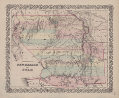
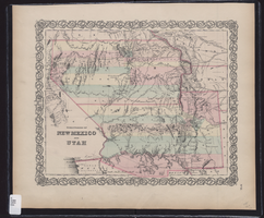
Map of territories of New Mexico and Utah, 1855
Date
1855
Description
29 x 36 cm. Shows natural features, and populated places, wagon route, proposed railroad routes and explorers' routes. Relief shown by hachures. Prime meridians: Greenwich and Washington. "Entered according to act of Congress in the year 1855 by J.H. Colton & Co in the Clerk's Office of the District Court of the U.S. for the Southern District of New York." Hand colored. Atlas p. number in lower-right margin: 51. Decorative border. The geographic region of Southwest is referred to as the New Southwest. Original publisher: J.H. Colton .
Image
Southwest regional subject files, 1993-2012
Level of Description
Sub-Series
Scope and Contents
The Southwest regional subject files include materials about Native American communities and gaming in Arizona, Colorado, and New Mexico, dating from approximately 1993 to 2011. The materials include socioeconomic reports, tribal-state gaming compacts, journal articles, correspondence, Dr. Spilde’s research photographs, annual reports, brochures, booklets, Native American newspapers, conference materials, periodicals, promotional materials, and newspaper articles. The Southwest series focuses primarily on gaming, sociocultural, and economic topics in Arizona and New Mexico. Materials also document the gaming enterprises and community life of various Native American nations.
Archival Collection
Katherine A. Spilde Papers on Native American Gaming
To request this item in person:
Collection Number: MS-00092
Collection Name: Katherine A. Spilde Papers on Native American Gaming
Box/Folder: N/A
Collection Name: Katherine A. Spilde Papers on Native American Gaming
Box/Folder: N/A
Archival Component

Map of California, territories of New Mexico, Arizona, Colorado, Nevada and Utah, circa 1863
Date
1861 to 1865
Description
40 x 62 cm. Relief shown by hachures and spot heights. Prime meridians: Greenwich and Washington. "Historical and statistical view of the United States, 1860"--Verso. Atlas page numbers at top: 58-59. Arizona became a territory in 1863, and Nevada became a state on October 31, 1864, so this map was either published in 1863 or in 1864 before the end of October. Original publisher: Johnson and Ward.
Image

Map of California, with territories of Utah, Nevada, Colorado, New Mexico, and Arizona, 1864
Date
1864
Description
40 x 62 cm. Relief shown by hachures. Prime meridians: Greenwich and Washington. Page numbers at top: 58-59. "Entered according to act of Congress in the year 1864 by A. J. Johnson in the Clerk's Office of the District Court of the United States for the Southern District of New York." Original publisher: Johnson and Ward.
Image

Map of California and Territories of New Mexico and Utah, 1862
Date
1862
Description
Scale [ca. 1:3,231,360. 1 in. to approx. 51 miles] (W 125°00--W 103°30/N 42°00--N 31°45) ; 1 map : hand col. ; 40 x 60 cm., on sheet 46 x 68 cm ; Relief indicated by hachures and spot heights ; Prime meridians: Greenwich and Washington, D.C ; Decorative border ; Hand colored ; Atlas p. numbers in upper margin: 58-59 ; Date est. from territorial borders and county configuration ; Shows natural features, locations of Indian tribes, proposed railroad routes, routes of explorers, trails, county boundaries and populated places ; Johnson and Ward
Image
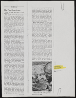
"And Justice for All: Part III": article draft by Roosevelt Fitzgerald
Date
1980 (year approximate) to 1995 (year approximate)
Archival Collection
Description
From the Roosevelt Fitzgerald Professional Papers (MS-01082) -- Drafts for the Las Vegas Sentinel Voice file. On law enforcement mistreatment/discrimination Mexican Americans.
Text
Map showing the territories of New Mexico and Utah, 1855
Date
1855
Description
'Entered according to Act of Congress in the year 1855 by J.H. Colton & Co. in the Clerk's Office of the Dist. Court of the U.S. for the South'n. Dist. of New York.' Scale [ca. 1:4,752,000. 1 in. to approx. 75 miles] (W 120°--W 102°/N 43°--N 32°). Shows natural features, and populated places, wagon route, proposed railroad routes and explorers' routes. Relief shown by hachures. Prime meridians: Greenwich and Washington.Hand colored. Atlas p. number in lower-right margin: 51. Decorative border. J.H. Colton & Co.
Image