Search Results

Maps of explorations and surveys for a railroad route from the Mississippi River to the Pacific Ocean, 1855
Date
1855
Description
Map no. 1. From the valley of Green River to the Great Salt Lake -- Map no. 2. From the Great Salt Lake to the Humboldt Mountains -- Map no. 3. From the Humboldt Mountains to the Mud Lakes -- Map no. 4. From the valley of the Mud Lakes to the Pacific Ocean. 'From explorations and surveys made under the direction of the Hon. Jefferson Davis, Secretary of War, by Capt. E.G. Beckwith, 3rd Artillery, E.G. Egloffstein, topographer for the route. 1855.' ''Selmar Siebert's Engraving & Printing Establishment, Washington, D.C.' Published by the War Dept. Scale 1:760,320. 12 miles to 1 in. Relief shown by hachures and spot heights.
Image
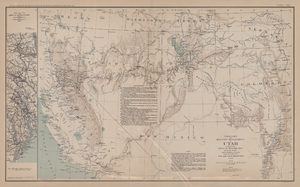
Map of territory and military department of Utah, 1860
Date
1860
Description
Compiled in the Bureau of Topographical Engineers of the War Department. Chiefly for Military purposes under the authority of Honorable J.B. Floyd, Secretary of War, 1860. 42 x 69 cm. Shows towns, wagon roads, explorers' routes, railroads, forts, etc., approx. from Albuquerque, N.M. to Fort Lane, Or. and from Fort Laramie, Wyo. to Los Angeles, Calif. "Corrections and additions in reference to railroads in California, etc., were made in January, 1862 ..." "The new military posts at Fort Bidwell, ... located from a map loaned ... January 16, 1866." "Atlas to accompany the official records of the Union and Confederate armies, 1861-1865. Plate CXX."--Upper margin. Atlas published by the Washington Government Printing Office in 1891-95. Relief shown by hachures. "Julius Bien & Co. Lith. N.Y." Includes text and list of authorities. Inset: March routes of Army of the Tennessee from Savannah, Ga., to Columbia, S.C., 1865, accompanying the report of Maj. Gen O.O. Howard, U.S. Army, series I, vol. XLVII, part I. Includes bibliographical references. Washington Territory is shown prior to becoming Washington state. The geographic region of Southwest is referred to as the New Southwest. Original publisher: Govt. Print. Off..
Image
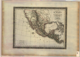
Map of Mexico and Central America, 1826
Date
1826
Description
'Par L. Vivien, Géographe, Gravée par Giraldon-Bovinet. 1826, Paris. Chez Ménard & Desenne, Rue Git-le-Coeur, No. 8.' Scale [ca. 1:15,840,000] (W 125°--W 75°/N 35°--N 05°). Relief shown by hachures. Hand colored. Atlas plate number in upper margin: no. 34. Ménard & Desenne
Image
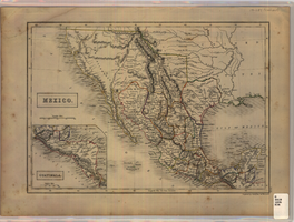
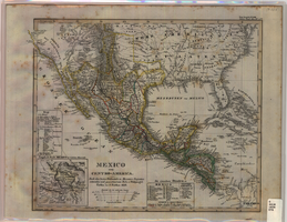
Map of Mexico, circa 1830s-1840s
Date
1830 to 1849
Description
'Engraved by S. Hall, Bury Strt., Bloomsby.' Inset map: Guatimala [sic] (including Honduras and Belize). Includes area of Southwestern states. Scale [ca. 1:12,400,000. 1 in. to approx. 200 miles] (W 125°-- W 85°/N 40°--N 15°). Relief shown by hachures. Prime meridian: Greenwich. Hand colored. 'XLIX'--outside of border at the lower right-hand. Published between 1836 and 1845?
Image
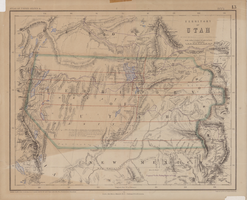
Map of territory of Utah, 1857
Date
1857
Description
31 x 39 cm. Relief shown by hachures and spot heights. "Entered in Sta. Hall London & according to act of Congress in the year 1857 by H.D. Rogers in the Clerks Office of the District Court of Massachusetts." Includes proposed Pacific railway routes. In upper margin: Atlas of United States &c., 13. Original publisher: John Murray, Scale: 3,450,000 of nature, 54 1.
Image
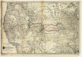
Map showing the Union Pacific Railway and connecting railroads, 1888
Date
1882
Description
Scale 1:3,800,000. 1 in. to 60 miles (W 126°--W 86°/N 48°--N 30°) ; 1 map : col. ; 57 x 85 cm ; Relief shown by hachures ; Prime meridian: Greenwich and Washington, D.C. ; "Entered according to act of Congress in the year 1882 by G.W. & C.B. Colton & Co. in the office of the Librarian of Congress, at Washington." ; Rufus Adams
Image
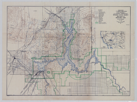
Topographic map of Boulder Canyon Project, Boulder Dam area, 1940
Date
1940
Description
Scale [ca. 1:221,760. 1 in. to approx. 3.5 miles] ; 1 map : col. ; 51 x 71 cm ; Relief shown by contours and spot heights ; Includes township and range grid ; "Map no. 40-40" ; Includes index map ; Shows power lines, triangulation stations, boundary monuments, roads, telephone lines, mines, bench marks, etc. ; U.S. Dept. of the Interior, Bureau of Reclamation
Image
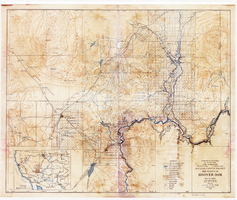
Topographic map of Boulder Canyon Project, Hoover Dam area, 1932
Date
1932
Description
Scale [ca. 1:221,760. 1 in. to approx. 3.5 miles] ; 1 map : col. ; 51 x 62 cm ; Relief shown by contours and spot heights ; "Prepared in Washington Office from compilation made in Las Vegas Office." ; "Map no. 24000." ; Includes township and range grid ; Shows power lines, triangulation stations, boundary monuments, roads, telephone lines, mines, bench marks, etc. ; Department of the Interior, Bureau of Reclamation.
Image
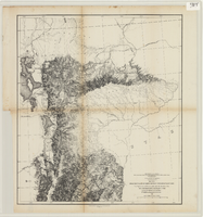
From the valley of Green River to the Great Salt Lake
Date
1855
Description
'From explorations and surveys made under the direction of the Hon. Jefferson Davis, Secretary of War, by Capt. E.G. Beckwith, 3rd Artillery, E.G. Egloffstein, topographer for the route. 1855.' ''Selmar Siebert's Engraving & Printing Establishment, Washington, D.C.' Published by the War Dept. Scale 1:760,320. 12 miles to 1 in. Relief shown by hachures and spot heights.
Image
Map of Mexico and Central America, 1828
Date
1828
Description
Includes southwestern and southeastern United States and parts of the Caribbean islands. 'Nach den besten Hülfsmitteln in Mercators Projection entworfen und gezeichnet vom Pr.L. v. Stülpnagel. Gotha, bei J. Perthes, 1828.' Scale ca. 1:14,000,000 ; Mercator projection. Relief shown by hachures. Prime meridian: Washington, D.C. Inset: 'Umgeb d. Stadt Mexico in 4 fachen Maasstab [sic].' Hand colored. In upper right corner: 'Neue Ausgabe No. LVIII. Stielers Hand-Atlas (no.47b).' Includes index. Includes southern United States and part of West Indies. J. Perthes
Image