Search Results
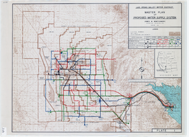
Topographic map of master plan for proposed water supply system for Las Vegas Valley Water District, August 1960
Date
Description
Image
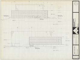
Architectural drawing of Performing Arts Center, Phase II, University of Nevada, Las Vegas, exterior elevations, July 31, 1974
Date
Archival Collection
Description
East and south exterior elevations of Performing Arts Center (later to become the Judy Bayley Theatre), University of Nevada, Las Vegas. Scale: 1/8" = 1'-0". "Drawn by J.A.L. Checked by O.D.S. Job no. 720. Date 7-31-74." "Sheet A-7 of 28."
Site Name: University of Nevada, Las Vegas
Address: 4505 S. Maryland Parkway
Image
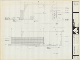
Architectural drawing of Performing Arts Center, Phase II, University of Nevada, Las Vegas, exterior elevations, July 31, 1974
Date
Archival Collection
Description
West and north exterior elevations of Performing Arts Center (later to become the Judy Bayley Theatre), University of Nevada, Las Vegas. Scale: 1/8" = 1'-0". "Sheet A-8 of 28." "Drawn by J.A.L. Checked by O.D.S. Job no. 720. Date 7-31-74."
Site Name: University of Nevada, Las Vegas
Address: 4505 S. Maryland Parkway
Image
Las Vegas High School Tales of Las Vegas Collection
Identifier
Abstract
The Las Vegas High School Tales of Las Vegas Collection consists of two hand-bound books written by the 1924 modern history class and the 1925 United States history class at Las Vegas High School. The two books, both entitled "Tales of Las Vegas", chronicle Las Vegas, Nevada history starting in the 17th century with the Spanish Jesuit and Franciscan Monks. The books then focus on the 1905 "boom" stage of Las Vegas, discussing topics including Mormons, Native Americans, and mining. The two books are similar in content but not identical, and both contain photographs of early Las Vegas, Nevada life.
Archival Collection
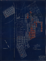
Map showing general plan for the district boundary of Lateral Sanitary Sewer District No. 1, Las Vegas, Nevada, circa 1928
Date
Description
Image
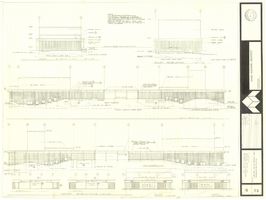
Architectural drawing of concert hall and drama theater, University of Nevada, Las Vegas, exterior elevations, November 5, 1969
Date
Archival Collection
Description
Exterior elevations for the concert hall and drama theater on the University of Nevada, Las Vegas campus, including a connecting courtyard. These buildings would become the Artemus W. Ham Concert Hall and the Judy Bayley Theatre. Sheet 6 of 35. "Drawn by G.T. Checked by K.D. Job number 6828. Scale 1/16" = 1'-0". Date Nov. 5, 1969"
Site Name: University of Nevada, Las Vegas
Address: 4505 S. Maryland Parkway
Image

General geologic map of Las Vegas, Pahrump, and Indian Spring Valleys, Clark and Nye Counties, Nevada, 1948
Date
Description
At top of map: 'United States Department of the Interior, Geological Survey. State Engineer of Nevada. Water resources bulletin No. 5, Plate 1.' Relief shown by spot heights. Includes 3 inset maps of wells and springs in the vicinity of Pahrump, Manse Ranch and Indian Springs, Nevada. Scale [ca. 1:126,720. 1 inch to approx. 2 miles] (W 116°--W 115°/N 40°--N 36°). Originally published as plate 1 in Geology and water resources of Las Vegas, Pahrump, and Indian Spring Valleys, Clark and Nye Counties, Nevada by George B. Maxey and C.H. Jameson (1948), which is number 5 of the Water resources bulletin published by the Nevada Office of the State Engineer.
Image
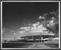
Photograph of Las Vegas Convention Center, Las Vegas, 1966
Date
Archival Collection
Description
Image
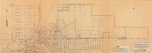
Map showing location of leased properties proposed to be sold to the Las Vegas Land and Water Company, October 2, 1952
Date
Archival Collection
Description
Image
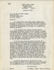
Letter from Robert E. Jones (Las Vegas) to Las Vegas Land and Water Company (Las Vegas), January 18, 1949
Date
Archival Collection
Description
Las Vegas Valley Water District lawyers broaching the subject of purchasing the Las Vegas Land and Water Company
Text