Search the Special Collections and Archives Portal
Search Results

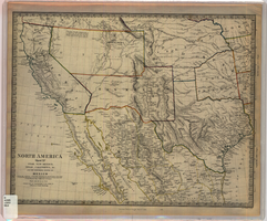
Map of Utah, New Mexico, Texas, California, Indian territory, and the northern states of Mexico, 1852
Date
1852-01-01
Description
At head of title: 'North America, sheet XV.' 'Published under the superintendence of the Society for Diffusion of Useful Knowledge.' At bottom center of map:'London, Charles Knight, Jany. 1st, 1852.' At bottom right of map: ' J. & C. Walker Sculpt.' Scale [1:7,500,000] 1 degree to 68.89 English miles (W 125°--W 92°/N 43°30?--N 22°30?). Relief shown by hachures. Atlas page number in lower margin: 144. Boundaries hand colored. Includes notes, locations of Indian tribes, population statistics. Charles Knight.
Image
View of George Washington Bridge to the Verazano Bridge in Manhattan from across the Hudson River, New York City, New York: panoramic photograph, 1980 May 28
Level of Description
Item
Archival Collection
Bob Paluzzi Panoramic Photographs
To request this item in person:
Collection Number: PH-00414
Collection Name: Bob Paluzzi Panoramic Photographs
Box/Folder: Box 04, Digital File 00
Collection Name: Bob Paluzzi Panoramic Photographs
Box/Folder: Box 04, Digital File 00
Archival Component
Pagination
Refine my results
Content Type
Creator or Contributor
Subject
Archival Collection
Digital Project
Resource Type
Year
Material Type
Place
Language
Records Classification

