Search Results
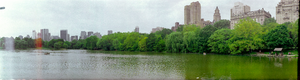
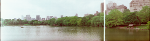
Central Park, New York City, New York: panoramic photographs
Date
1981-05-31
Archival Collection
Description
From the Bob Paluzzi Panoramic Photographs
Image
Report: "Study of Betting on Sports in New York City" by the Fund for the City of New York Quayle Survey
Level of Description
File
Archival Collection
Eugene Martin Christiansen Papers
To request this item in person:
Collection Number: MS-00561
Collection Name: Eugene Martin Christiansen Papers
Box/Folder: Box 168
Collection Name: Eugene Martin Christiansen Papers
Box/Folder: Box 168
Archival Component
"The New York City Office of the Comptroller Discussion Materials Regarding New York City OTB", 2007
Level of Description
File
Archival Collection
Eugene Martin Christiansen Papers
To request this item in person:
Collection Number: MS-00561
Collection Name: Eugene Martin Christiansen Papers
Box/Folder: Box 069
Collection Name: Eugene Martin Christiansen Papers
Box/Folder: Box 069
Archival Component

New York City Center, undated
Level of Description
File
Archival Collection
JMA Architecture Studio Records
To request this item in person:
Collection Number: MS-00783
Collection Name: JMA Architecture Studio Records
Box/Folder: Box 89
Collection Name: JMA Architecture Studio Records
Box/Folder: Box 89
Archival Component

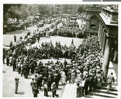
Photograph of crowds for Howard Hughes outside of City Hall, New York City, July 15, 1938
Date
1938-07-15
Archival Collection
Description
The view of a crowd standing outside City Hall while Howard Hughes and his crew get their picture taken in celebration of Hughes' completion of his Round the World flight in New York City, New York.
Image
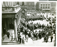
Photograph of crowds for Howard Hughes outside of City Hall, New York City, July 15, 1938
Date
1938-07-15
Archival Collection
Description
The black and white view of a crowd standing outside City Hall while Howard Hughes and his crew get their picture taken in celebration of Hughes' completion of his Round the World flight in New York City, New York.
Image