Search the Special Collections and Archives Portal
Search Results
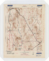
Topographic map of the Camp Mohave quadrangle in California, Nevada and Arizona, 1942
Date
1942
Description
Scale 1;250,000 ; polyconic projection (W 115°--W 114V/N 36V--N 35V) ; 1 map : col. ; 52 x 37 cm ; Relief shown by contours and spot heights. Contour interval 250 feet ; "Training map"--Center of upper margin of map ; "Base compiled from U.S. Geological Survey quadrangles. Control from U.S. Geological Survey. Revised from state highway maps for Arizona, Nevada and California" ; "Culture revisions shown in red based on reconnaissance by 67th Engr. Co. (Top.). May not be of same accuracy as base map." ; Map shows roads, trails, ponton sites, dam sites, possible air fields, possible landing fields, airports, water points, and impassable areas ; Map was originally restricted. "Classification cancelled by authority of Chief of Engineers letter of Jan. 22, 1946." ; Title at top of map: Nevada-Arizona-California : Camp Mohave quadrangle : grid zone F ; Army Map Service, U.S. Army.
Image
Pagination
Refine my results
Content Type
Creator or Contributor
Subject
Archival Collection
Digital Project
Resource Type
Year
Material Type
Place
Language
Records Classification


