Search Results

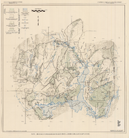
Map of Lincoln County, Nevada and Mohave County, Arizona area, 1892
Date
1892
Description
'Henry Gannett, chief geographer ; A.H. Thompson, geographer in charge ; triangulation by H.M. Wilson ; topography by H.M. Wilson and Powell survey.' 'Edition of Mar. 1892, reprinted 1929.' Handwritten legend on right-side margin of map. Original publisher: Dept. of the Interior, U.S. Geological Survey. Scale 1:250,000
polyconic proj. (W 115°--W 114°/N 37°--N 35°).
polyconic proj. (W 115°--W 114°/N 37°--N 35°).
Image
Nye County county office remodel, 1991
Level of Description
File
Archival Collection
Alton Dean Jensen Architectural Records
To request this item in person:
Collection Number: MS-00843
Collection Name: Alton Dean Jensen Architectural Records
Box/Folder: Box 267
Collection Name: Alton Dean Jensen Architectural Records
Box/Folder: Box 267
Archival Component
County Accomplishments. Contains, by County, HWC accomplishments
Level of Description
File
Archival Collection
Howard Cannon Papers
To request this item in person:
Collection Number: MS-00002
Collection Name: Howard Cannon Papers
Box/Folder: Box 05 (Las Vegas files)
Collection Name: Howard Cannon Papers
Box/Folder: Box 05 (Las Vegas files)
Archival Component
Clark County, Nevada School District Annual Reports
Identifier
MS-00665
Abstract
The Clark County, Nevada School District Annual Reports include reports created by the Clark County School District from 1970 to 1980. Reports for the school years of 1972 to 1973, 1973 to 1974, and 1976 to 1977 are not included.
Archival Collection
Generalized hydrogeologic map of lower Moapa-Lake Mead area, Clark County, Nevada, 1968
Date
1968
Description
'Hydrogeology by F.E. Rush, 1968. Geology adapted from Longwell and others 1965.' In lower left corner: ' Base: U.S. Geological Survey 1:250,000 topographic series; Las Vegas (1954).' At top of map: 'United States Department of the Interior, Geological Survey. Department of Conservation and Natural Resources, State of Nevada.' Relief shown by contoursIncludes township and range lines. Scale 1:250,000 (W 115°00´--W 114°15´/N 36°30´--N 36°15´). Series: Water resources-reconnaissance series report . Originally published as plate 1 in Water-resources appraisal of the lower Moapa-Lake Mead area, Clark County, Nevada / by F. Eugene Rush, published by State of Nevada Dept. of Conservation and Natural Resources in 1968 in volume 50 of the serial Water resources-reconnaissance series report.
Image
Economic Opportunity Board of Clark County (Nev.): rosters, correspondence
Date
1964 to 1970
Archival Collection
Description
From the Clark County Economic Opportunity Board Records -- Series I. Administrative. This folder contains reports, correspondence, and rosters of the Economic Opportunity Board of Clark County, Nevada from 1964 through 1970.
Text
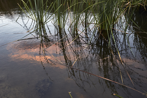
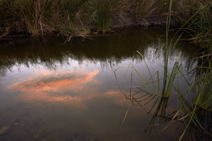
Clark County Wetlands Park, Clark County, Nevada: digital photograph
Date
2016-07-09
Archival Collection
Description
The sunset is reflected in a settling pond at the Clark County Wetlands Park.
Image

Clark County Wetlands Park, Clark County, Nevada: digital photograph
Date
2016-07-09
Archival Collection
Description
The sunset is reflected in a settling pond at the Clark County Wetlands Park.
Image
Clark County Wetlands Park, Clark County, Nevada: digital photograph
Date
2016-07-09
Archival Collection
Description
The sunset is reflected in a settling pond at the Clark County Wetlands Park.
Image