Search Results

Map of Las Vegas Rancho, Lincoln County, Nevada, September 15, 1904
Date
Description
Image
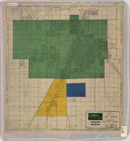
Map of Las Vegas and vicinity, Clark County, Nevada, April 15, 1951
Date
Description
Image
Lincoln County Museum Photograph Collection
Identifier
Abstract
The Lincoln County Museum Photograph Collection contains photographs of towns, railroads, and mining operations in Lincoln County, Nevada from 1870 to 1953. The photographs primarily depict mines and railroads in Pioche, Caliente, Bullionville, and Panaca from 1900 to 1908 during part of Nevada’s mining boom. The photographs also depict Paiute workers, horse freight teams, geographical landmarks, and students in Lincoln County.
Archival Collection

Geologic map of the northeast quarter of the Bullfrog 15-minute quadrangle, Nye County, Nevada, 1990
Date
Description
Image
Clark County Mother of the Year Records
Identifier
Abstract
The Clark County Mother of the Year Records (1970-1988) provide information about the annual award ceremony in Clark County, Nevada and its recipients. Included are newspaper clippings, press releases, correspondence, and biographies of the award winners.
Archival Collection
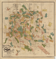
Map of the Goldfield Mining District, Nye and Esmeralda Counties, Nevada, 1905
Date
Description
Image

Map of Las Vegas and vicinity, Clark County, Nevada, November 1952
Date
Description
Image

General geologic map of Las Vegas, Pahrump, and Indian Spring Valleys, Clark and Nye Counties, Nevada, 1948
Date
Description
At top of map: 'United States Department of the Interior, Geological Survey. State Engineer of Nevada. Water resources bulletin No. 5, Plate 1.' Relief shown by spot heights. Includes 3 inset maps of wells and springs in the vicinity of Pahrump, Manse Ranch and Indian Springs, Nevada. Scale [ca. 1:126,720. 1 inch to approx. 2 miles] (W 116°--W 115°/N 40°--N 36°). Originally published as plate 1 in Geology and water resources of Las Vegas, Pahrump, and Indian Spring Valleys, Clark and Nye Counties, Nevada by George B. Maxey and C.H. Jameson (1948), which is number 5 of the Water resources bulletin published by the Nevada Office of the State Engineer.
Image
Lincoln County Archaeological Initiative Collection
Identifier
Abstract
The Lincoln County Archaeological Initiative Collection (2016-2019) contains digital files of oral histories collected as part of A Ranching and Farming Context for Lincoln County, Nevada, ca. 1857 to 1934 (Oliver et al. 2018). The collection consists of thirteen digital oral history recordings and corresponding transcripts, as well as a final report of phase one of the project. The entire collection is digital files.
Archival Collection
Economic Opportunity Board of Clark County (Nev.): rosters, correspondence
Date
Archival Collection
Description
From the Clark County Economic Opportunity Board Records -- Series I. Administrative. This folder contains reports, correspondence, and rosters of the Economic Opportunity Board of Clark County, Nevada from 1964 through 1970.
Text