Search Results
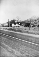
Hot springs located a few miles north of Beatty, Nevada: photographic print
Date
1930
Archival Collection
Description
From the Nye County, Nevada Photograph Collection (PH-00221) -- Series III. Beatty, Nevada -- Subseries III.F. Palsgrove Family. At one time the hot springs was a stop on the Bullfrog Goldfield Railroad, which linked Rhyolite and Goldfield. The building pictured is the old station house for the railroad.
Image
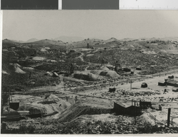
Photograph of Goldfield Mining District in Goldfield (Nev.), 1907
Date
1907
Archival Collection
Description
Goldfield Mining District, Goldfield, NV, 1907. There is an inscription on the back of the image: "Looking east from Florence hill. The numerous mines are only a few of the hundreds operating the district at the time. The newly completed tracks of the Bullfrog Goldfield Railroad, one of four serving Goldfield, can be seen in the center of the photo. Milltown, one of Goldfield's four satellite camps, appears on the right." There is a date stamp: 1985.
Image
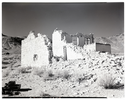
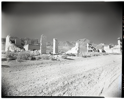
Film transparency of the ruins of the H. D. and L. D. Porter Brothers Store, Rhyolite, Nevada, November 25, 1948
Date
1948-11-25
Archival Collection
Description
An unidentified person looks at the ruins of the H. D. and L. D. Porter Brothers Store in Rhyolite, Nevada. The remains of two wooden buildings and several mining tailing piles are visible in the background. Originally from Illinois, the brothers opened their first store in Johannesburg, Ca. in 1902. Moving with the mining booms, they opened stores in Ballarat, Beatty, Pioneer and Rhyolite. From the Ballarat store, H. D. Porter loaded thirty tons of merchandise onto an 18-mule team freight wagon and came east across Death Valley to the Bullfrog District. The original store was built on Main St. After the move to Golden St., the wooden building was used as a furniture store for the Porter Brothers. With the purchase of a lot on Golden Ave. the construction of a new stone building began in July 1906 and was finished four months later. According to the Rhyolite Herald, November 1906 "This is a large substantial structure, practically fireproof, and occupies a prominent site on Golden Street. The main floor is 30 x 80 feet, with a basement and gallery." Nels Linn was the contractor who did the stonework. The estimated cost was $10,000 for the complete construction of the building. One of the signs that hung from the Porter Brothers Store was "All Things Good But Whiskey". With all the saloons already established in Rhyolite, the Porter Brothers maintained a reputation of never selling liquor. Rhyolite is a ghost town in Nye County, Nevada. It is in the Bullfrog Hills, about 120 miles (190 km) northwest of Las Vegas, near the eastern edge of Death Valley. The town began in early 1905 as one of several mining camps that sprang up after a prospecting discovery in the surrounding hills. During an ensuing gold rush, thousands of gold-seekers, developers, miners and service providers flocked to the Bullfrog Mining District. Many settled in Rhyolite, which lay in a sheltered desert basin near the region's biggest producer, the Montgomery Shoshone Mine. Rhyolite declined almost as rapidly as it rose. After the richest ore was exhausted, production fell. The 1906 San Francisco earthquake and the financial panic of 1907 made it more difficult to raise development capital. In 1908, investors in the Montgomery Shoshone Mine, concerned that it was overvalued, ordered an independent study. When the study's findings proved unfavorable, the company's stock value crashed, further restricting funding. By the end of 1910, the mine was operating at a loss, and it closed in 1911. By this time, many out-of-work miners had moved elsewhere, and Rhyolite's population dropped well below 1,000. By 1920, it was close to zero. After 1920, Rhyolite and its ruins became a tourist attraction and a setting for motion pictures. Most of its buildings crumbled, were salvaged for building materials, or were moved to nearby Beatty or other towns, although the railway depot and a house made chiefly of empty bottles were repaired and preserved. The town is named for rhyolite, an igneous rock composed of light-colored silicates, usually buff to pink and occasionally light gray. It belongs to the same rock class, felsic, as granite but is much less common.
Image
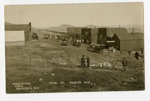
Photograph of people, automobiles and wagons on Main Street, Pioneer (Nev.), 1900-1925
Archival Collection
Description
Inscription on front reads: Welch & Tune Photo Goldfield Goldfield Nev Main St. Pioneer Nev. Per patron comment, the second business from the left is the Vienna Bakery Cafe, and a fire started there on May 7, 1909 that burned down all of the businesses in that row. Patron also noted that the sign on the back of the car reads "Alkali Bill's Auto Line," and this was a company that provided transportation from the Bullfrog Goldfield Railroad depot in Springfield to Pioneer.
Image
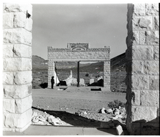
Film transparency of the ruins of possibly the John T. Overbury building, Rhyolite, Nevada, November 25, 1948
Date
1948-11-25
Archival Collection
Description
Film transparency of the ruins of possibly the John T. Overbury building, Rhyolite, Nevada. Rhyolite is a ghost town in Nye County, Nevada. It is in the Bullfrog Hills, about 120 miles (190 km) northwest of Las Vegas, near the eastern edge of Death Valley. The town began in early 1905 as one of several mining camps that sprang up after a prospecting discovery in the surrounding hills. During an ensuing gold rush, thousands of gold-seekers, developers, miners and service providers flocked to the Bullfrog Mining District. Many settled in Rhyolite, which lay in a sheltered desert basin near the region's biggest producer, the Montgomery Shoshone Mine. Rhyolite declined almost as rapidly as it rose. After the richest ore was exhausted, production fell. The 1906 San Francisco earthquake and the financial panic of 1907 made it more difficult to raise development capital. In 1908, investors in the Montgomery Shoshone Mine, concerned that it was overvalued, ordered an independent study. When the study's findings proved unfavorable, the company's stock value crashed, further restricting funding. By the end of 1910, the mine was operating at a loss, and it closed in 1911. By this time, many out-of-work miners had moved elsewhere, and Rhyolite's population dropped well below 1,000. By 1920, it was close to zero. After 1920, Rhyolite and its ruins became a tourist attraction and a setting for motion pictures. Most of its buildings crumbled, were salvaged for building materials, or were moved to nearby Beatty or other towns, although the railway depot and a house made chiefly of empty bottles were repaired and preserved. The town is named for rhyolite, an igneous rock composed of light-colored silicates, usually buff to pink and occasionally light gray. It belongs to the same rock class, felsic, as granite but is much less common.
Image
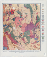
Geologic reconnaissance map of portions of southwestern Nevada and eastern California, 1905
Date
1905
Description
At top of map: 'U.S. Geological Survey, Charles D. Walcott, director.' At bottom of map: 'E.M. Douglas, Geographer. R.H. Chapman, in charge of section.Triangulation and topography by R.H. Chapman and B.D. Stewart. Surveyed in 1905.' 'Geology by Sydney H. Ball. Geology in immediate vicinity of Goldfield and Bullfrog generalized from maps by F.L. Ransome assisted by George H. Garrey and W.H. Emmons.' Scale 1:250,000 (W 117°30--W 116°/N 38°--N 36°)
Image
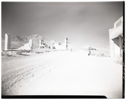
Film transparency of a boy looking at an abandonded building, Rhyolite, Nevada, November 25, 1948
Date
1948-11-25
Archival Collection
Description
A young boy looks at the ruins of the H. D. and L. D. Porter Brothers Store in Rhyolite, Nevada. Several other buildings are visible in the background. Rhyolite is a ghost town in Nye County, Nevada. It is in the Bullfrog Hills, about 120 miles (190 km) northwest of Las Vegas, near the eastern edge of Death Valley. The town began in early 1905 as one of several mining camps that sprang up after a prospecting discovery in the surrounding hills. During an ensuing gold rush, thousands of gold-seekers, developers, miners and service providers flocked to the Bullfrog Mining District. Many settled in Rhyolite, which lay in a sheltered desert basin near the region's biggest producer, the Montgomery Shoshone Mine. Rhyolite declined almost as rapidly as it rose. After the richest ore was exhausted, production fell. The 1906 San Francisco earthquake and the financial panic of 1907 made it more difficult to raise development capital. In 1908, investors in the Montgomery Shoshone Mine, concerned that it was overvalued, ordered an independent study. When the study's findings proved unfavorable, the company's stock value crashed, further restricting funding. By the end of 1910, the mine was operating at a loss, and it closed in 1911. By this time, many out-of-work miners had moved elsewhere, and Rhyolite's population dropped well below 1,000. By 1920, it was close to zero. After 1920, Rhyolite and its ruins became a tourist attraction and a setting for motion pictures. Most of its buildings crumbled, were salvaged for building materials, or were moved to nearby Beatty or other towns, although the railway depot and a house made chiefly of empty bottles were repaired and preserved. The town is named for rhyolite, an igneous rock composed of light-colored silicates, usually buff to pink and occasionally light gray. It belongs to the same rock class, felsic, as granite but is much less common.
Image
Film transparency of buildings located on Golden Street, Rhyolite, Nevada, November 25, 1948
Date
1948-11-25
Archival Collection
Description
Two buildings that were located on Golden Street in Rhyolite, Nevada. The building on the left was possibly the John T. Overbury building. The building on the right was the John S. Cook & Co. Bank building. Rhyolite is a ghost town in Nye County, Nevada. It is in the Bullfrog Hills, about 120 miles (190 km) northwest of Las Vegas, near the eastern edge of Death Valley. The town began in early 1905 as one of several mining camps that sprang up after a prospecting discovery in the surrounding hills. During an ensuing gold rush, thousands of gold-seekers, developers, miners and service providers flocked to the Bullfrog Mining District. Many settled in Rhyolite, which lay in a sheltered desert basin near the region's biggest producer, the Montgomery Shoshone Mine. Rhyolite declined almost as rapidly as it rose. After the richest ore was exhausted, production fell. The 1906 San Francisco earthquake and the financial panic of 1907 made it more difficult to raise development capital. In 1908, investors in the Montgomery Shoshone Mine, concerned that it was overvalued, ordered an independent study. When the study's findings proved unfavorable, the company's stock value crashed, further restricting funding. By the end of 1910, the mine was operating at a loss, and it closed in 1911. By this time, many out-of-work miners had moved elsewhere, and Rhyolite's population dropped well below 1,000. By 1920, it was close to zero. After 1920, Rhyolite and its ruins became a tourist attraction and a setting for motion pictures. Most of its buildings crumbled, were salvaged for building materials, or were moved to nearby Beatty or other towns, although the railway depot and a house made chiefly of empty bottles were repaired and preserved. The town is named for rhyolite, an igneous rock composed of light-colored silicates, usually buff to pink and occasionally light gray. It belongs to the same rock class, felsic, as granite but is much less common.
Image