Search Results

Map of Las Vegas Valley, Clark County, Nevada, 1954
Date
Description
Image

Topographic map of the Las Vegas Valley and surrounding northern and western mountain ranges, 1943
Date
Description
Text
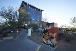
A mural on an electrical box outside of North Las Vegas City Hall, looking east in North Las Vegas, Nevada: digital photograph
Date
Archival Collection
Description
From the UNLV University Libraries Photographs of the Development of the Las Vegas Valley, Nevada (PH-00394). Part of the collection documents the entire 19 mile length of the north/south Eastern Avenue / Civic Center Drive alignment. This photograph was captured in the section of Civic Center Drive between Las Vegas Boulevard and Lake Mead Boulevard.
Image
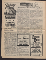
MS 95-47 Alice Key Collection. Box 1, Folder 07: Las Vegas Voice, July 21, 1966
Date
Archival Collection
Description
MS 95-47 Alice Key Collection. Box 1, Folder 07: Las Vegas Voice, July 21, 1966.
Text
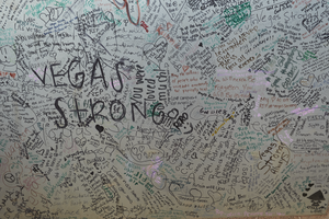
Messages, left as part of the 1 October memorial, cover a utility box near the Welcome to Las Vegas sign, looking west-southwest in Las Vegas, Nevada: digital photograph
Date
Archival Collection
Description
Following the October 1, 2017 killing of 58 people at the Route 91 Harvest Music Festival on the Las Vegas Strip, the Las Vegas community responded in a variety of ways. This series of photographs document the impromptu memorial created at the Welcome to Las Vegas sign.
Image

Blueprint map showing proposed changes to water system, Las Vegas Land & Water Co., Las Vegas, Nevada, circa 1936
Date
Archival Collection
Description
Image
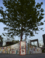
Hand painted tiles line the heart shaped planter box at the center of the Las Vegas Community Healing Garden, looking east in Las Vegas, Nevada: digital photograph
Date
Archival Collection
Description
Following the October 1, 2017 killing of 58 people at the Route 91 Harvest Music Festival on the Las Vegas Strip, the Las Vegas community responded in a variety of ways. Envisioned by activists and built by volunteers, the City of Las Vegas established the Las Vegas Community Healing Garden at 1015 S. Casino Center Boulevard to honor the victims and give family members and the community a place to gather to remember.
Image
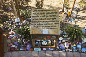
A box containing inscribed rocks for family members sits along the walkway at the Las Vegas Community Healing Garden, looking south in Las Vegas, Nevada: digital photograph
Date
Archival Collection
Description
Following the October 1, 2017 killing of 58 people at the Route 91 Harvest Music Festival on the Las Vegas Strip, the Las Vegas community responded in a variety of ways. Envisioned by activists and built by volunteers, the City of Las Vegas established the Las Vegas Community Healing Garden at 1015 S. Casino Center Boulevard to honor the victims and give family members and the community a place to gather to remember.
Image

Map of Las Vegas and vicinity, Clark County, Nevada, November 1952
Date
Description
Image

Topographic map of groundwater in the southwest quadrangle of Las Vegas, Nevada, 1985
Date
Description
Text