Search Results
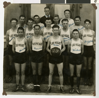
Photograph of the Las Vegas High School basketball team, Las Vegas (Nev.), 1929
Date
Archival Collection
Description
Image
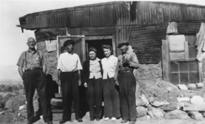
Home of "Seldom-Seen Slim," Ballarat, California in the foothills of the Panamint Mountains: photographic print
Date
Archival Collection
Description
From the Nye County, Nevada Photograph Collection (PH-00221) -- Series III. Beatty, Nevada -- Subseries III.B. Lisle Family. Matt Ryan, an employee of the U.S. Park Service; Seldom-Seen Slim; Lottie Mills, and mother Of Chloe Lisle; a woman who worked in Trona but whose name is not recalled; and Chris West, who lived up Surprise Canyon in the Panamint Mountains (identified from left to right).
Image
Charles P. Squires Photograph Collection
Identifier
Abstract
The Squires Family Photographs document the Squires Family and the development of the Las Vegas Valley in Nevada from approximately 1860 to 1980, with a bulk of the photographs depicting people and events from 1900 to 1950. The photographs depict the Euro-American settlement and growth of Las Vegas, Nevada; traveling and exploration of Southern Nevada and the Southwestern United States; the Hoover (Boulder) Dam and the Colorado River; clubs and social groups; and the Squires Family, especially prominent newspaper editor and publisher Charles Pember (C. P. or “Pop”) Squires, Delphine “Mom” Anderson Squires, and their children.
Archival Collection
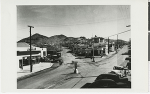
Photograph of Highway 95, Tonopah (Nev.), 1930s
Date
Archival Collection
Description
Old Highway 95 "Y" road in Tonopah, Nevada. Left road is Florence Ave., and right road is Highway to Goldfield, Nevada. On the left side of Florence Ave. is a Dodge Chrysler dealership. Gas stations line the right side of Florence Ave. including Texaco and Mobil Socony-Vacuum Oil Company (now known as ExxonMobil). The sign in the center of the road reads: "Ely Wells Salt Lake" with an arrow pointing left, and "Goldfield Beatty Las Vegas" with an arrow pointing right. Street Address: 210 Florence Ave
Image


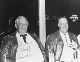
Deputy Sheriff Glen Henderson and Hank Records (identified from left to right).: photographic print
Date
Archival Collection
Description
From the Nye County, Nevada Photograph Collection (PH-00221) -- Series I. Amargosa Valley, Nevada -- Subseries I.B. Records Family. Nye County Deputy Sheriff Glen Henderson, whose area of responsibility included Beatty, the Amargosa Valley and Pahrump; at right, Hank Records, Amargosa Valley Farm Area pioneer; celebrating in their new leather jackets in Las Vegas, Nevada. Henderson's home in the Amargosa Valley became known locally as "Fort Henderson" and is sometimes still called that.
Image
