Search Results
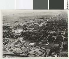
Aerial photograph of Las Vegas in the mid to late 1930s
Date
Archival Collection
Description
Aerial photo of Las Vegas looking south.
Transcribed Notes: Transcribed from photo sleeve: "[L. Foreground, old city hall. R. foreground, post office. Circular Park w/Boy scout structures (7)] "Aerial view of Las Vegas shows old park with race track (about where municipal swimming pool is) Small huts in group were Boy Scout huts made of stone. Scout troups met here surrounded by park taken middle or late 30's."- Dave Coons"
Image
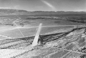
Aerial view of Airstrip: photographic print
Date
Archival Collection
Description
From the Nye County, Nevada Photograph Collection (PH-00221) -- Series IV. Pahrump, Nevada -- Subseries IV.D. Wiley Family. In the years after Roland Wiley acquired John Yount's ranch in Pahrump Valley, Nevada, access was difficult. From Las Vegas the shortest route was to drive through Goodsprings over a paved road, then to Sandy Valley, which was a narrow gravel road; then to the Pahrump Valley and west on the Tecopa Road. The trip took 3-1/2 hours. Wiley notes that from the ranch, it was a 7-hour round trip drive into Las Vegas to buy a 10-cent screw. In 1941, Roland constructed the airstrip pictured here near the ranch in order to make access easier.
Image
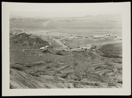
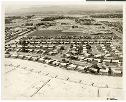
Aerial photograph of Boulder City (Nev.), circa 1933
Date
Archival Collection
Description
Image
Aerial views of Las Vegas Strip: video
Date
Archival Collection
Description
Aerial views of the Las Vegas Strip that starts in color and then shifts to black and white; includes views of MGM Grand, Vegas World, Sahara, Wet 'n Wild, Riveria, Circus Circus; switches back to color and the remainder is 360 views of the MGM Grand tower, marquee with Jubilee! sign, and neon signs during day and slowly fading into night shots. Original media 1 Inch SMPTE Type B, color, aspect ratio 4 x 3, frame size 720 x 486. From The Production Company Audiovisual Collection (MS-00930) -- Digitized audiovisual material file.
Moving Image

Aerial photograph of McCarran Airport and surrounding area, Las Vegas, Nevada, circa 1963
Date
Archival Collection
Description
Image
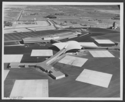
Aerial photograph of McCarran Airport and surrounding area, Las Vegas, Nevada, circa 1963
Date
Archival Collection
Description
Image
Stardust Hotel aerial advertising: video
Date
Archival Collection
Description
Moving Image
Aerial photograph of North Las Vegas, Nevada, June 5, 1973
Date
Archival Collection
Description
Image
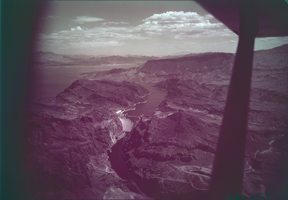
Film transparency showing an aerial view of Hoover Dam, circa mid 1950s
Date
Archival Collection
Description
Image
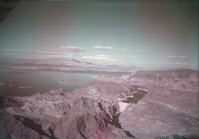
Film transparency showing an aerial view of Hoover Dam, circa mid 1950s
Date
Archival Collection
Description
Image