Search the Special Collections and Archives Portal
Search Results
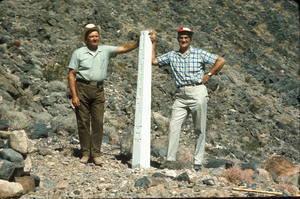
Slide of John Lytle at Emigrant (Fremont) Gap on the Old Spanish Trail, California, circa 1960s
Date
1960 to 1969
Archival Collection
Description
John Lytle (left) and Sherman "Scoop" Garside (right) at Emigrant (Fremont) Gap on the Old Spanish Trail. Emigrant Gap is a gap in a ridge on the California Trail as it crosses the Sierra Nevada, to the west of what is now known as Donner Pass. Here the cliffs are so steep that, back in the 1840s, the pioneers on their way to California had to lower their wagons on ropes in order to continue. The first official effort to mark the Old Spanish Trail across Nevada took place in 1964 when the Governor of Nevada asked Sherwin "Scoop" Garside to design and implement a Centennial project to help commemorate the Silver State's 100th birthday. Garside proposed that an appropriate Centennial project would be to mark the trace of the Old Spanish Trail across southern Nevada. The Governor concurred and directed the Nevada State government to cooperate in the project. Garside and his associate John Lytle brought together a group of friends and supporters to help fund and fabricate the white concrete posts that were used to mark the trace of the Old Spanish Trail across the state. Members of an affiliate of the local Boy Scouts of America Council helped erect thirty-three of these markers across the Mojave Desert in southern Nevada and Eastern California. The markers are inscribed with the legend "The Old Spanish Trail, 1829-1855." There are four Old Spanish Trail Historical Markers located in Nevada. One is located on U. S. 91 in Mesquite, the second is located in Fantasy Park, 1/4 mile east of Las Vegas Boulevard, North and Washington Avenue in Las Vegas, the third is located at Town Center in Blue Diamond, and the fourth is located on State 16 at Mountain Springs Summit. In 2001, the section of the Trail that runs across Nevada from the Arizona border to California (known as the "Old Spanish Trail-Mormon Road Historic District") was placed on the National Register of Historic Places.
Image
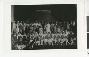
Photograph of Kiwanis Follies, Las Vegas (Nev.), April 30-May 1, 1928
Date
1928-04-30
1928-05-01
Archival Collection
Description
Kiwanis Follies members in a high school auditorium. This photograph was taken either April 30, 1928, or May 1, 1928. Photographed by the Myrtle M. Colaw Production Co. Depicted within the photograph are: Wally Rhoades, N,R, Burkhart, Gene Ward, Earl Farrar, Carl Trelease, Frank Diveney, Bill Davis, Glen Jarrit, Jim Downs, Sam Herman, Paris Stewart, Howard McMullen, Kendal Nungesser, Earl Davidson, Harley Harmon, Don Bremner, Geo. Hardman, W.J. Flowers, Bert Williams, Dr. Smith, Bill Fulton, Bill Schott, Bud Durkins, Doc Bullette, Parson Sloan, Doc Dixon, Tom Carrol, J.H. Down, Dean Bingham, Doc Myers, Doc Conger, Lestlie Edwards, Jack Pembroke, Cal Barnum, Ira Earl, Bill Johnson, Harry Anderson, A.S.Tract, Harve Perry, Hern Krause, Rosie Ward, John Mc Donald, Hal Buzick, Cub Ryerce, "Art" Harrington, Bus Squires, Harold Brinley, John Graglia, Earl Barr, Chas. ""Ted"" Rae, Dusty Rhoades, Dick Roschl, Bill Woodard, Steve Whitehead, Roscoe Thomas, Joh Miller, Vince C
Image
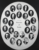
Photograph of Governors of Nevada plaque, Boulder City, Nevada, circa 1960s-1970s
Date
1960 to 1979
Archival Collection
Description
A plaque portraying the Governors of Nevada, acting and elected, in the Chamber of Commerce in Boulder City, Nevada. Description provided with image: "Pictured: 1. James W. Nye (1861-1864), 2. H.G. Blasdel (1864-1870), 3. L.R. Bradley (1871-1878), 4. John H. Kinkead (1879- 1882), 5. Jewett W. Adams (1883-1886), 6. C.C. Stevenson (1887-1890), 7. Frank Bell (1890), 8. R.K. Colcord (1891-1894), 9. John E. Jones (1895-1896), 10. Reinhold Sadler (1896-1902), 11. John Sparks (1903-1908), 12. Denver S. Dickerson (1908-1910), 13. Tasker L. Oddie (1911-1914), 14. Emmet D. Boyle (1915-1922), 15. Jas G. Scrugham (1923-1926), 16. Fred B. Balzar (1927-1934), 17. Morley Griswwold (1934), 18. Richard Kirman Sr. (1935-1938), 19. E.P. Carville (1939-1945), 20. Vail M. Pittman (1945- 1950), 21. Charles H. Russell (1951-1958), 22. Grant Sawyer (1959-1966), 23. Paul D. Laxalt (1967-)."
Image
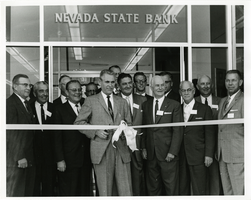
Photograph of Mayor Oran K. Gragson cutting the ribbon at the opening of Nevada State Bank, Las Vegas, Nevada, circa 1960s
Date
1960 to 1969
Archival Collection
Description
Las Vegas Mayor Oran K. Gragson cutting the ribbon at the opening of Nevada State Bank. The white-haired gentlemen standing to his left is former Nevada Governor Vail Pittman. Oran Kenneth Gragson (February 14, 1911 – October 7, 2002) was an American businessman and politician. He was the longest-serving mayor of Las Vegas, Nevada, from 1959 to 1975. Gragson, a member of the Republican Party, was a small business owner who was elected Mayor on a reform platform against police corruption and for equal opportunity for people of all socio-economic and racial categories. Gragson died in a Las Vegas hospice on October 7, 2002, at the age of 91. The Oran K. Gragson Elementary School located at 555 N. Honolulu Street, Las Vegas, NV 89110 was named in his honor. Vail Montgomery Pittman (September 17, 1880[a] – January 29, 1964) was an American politician. He was the 19th Governor of Nevada. He was a member of the Democratic Party. Pittman moved to Tonopah, Nevada in 1904 and began a successful newspaper publishing career. He met Ida Louise Brewington there and they married in Reno, Nevada on May 20, 1919. He and his wife bought the "Ely Daily Times" in Ely, Nevada and moved there in April of 1920 and began what was to be a very successful business. Elected to the Nevada State Senate, Pittman was in the position from 1925 to 1928. Pittman was elected the 19th Lieutenant Governor of Nevada in 1942. He was a candidate in the Democratic primary for United States Senate in 1944, but was defeated by the incumbent, Pat McCarran. He became governor when Edward P. Carville resigned in 1945. He was elected in 1946 to a term of his own and Pittman served until 1951. He and his wife moved back to Ely and continued operating the "Ely Daily Times" and traveling extensively. He served as a member of the 1960 Democratic National Committee.
Image
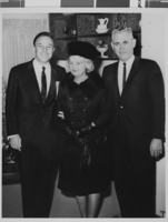
Photograph of Mayor Oran K. Gragson, his wife Bonnie with Gene Kelly, circa 1960s
Date
1960 to 1969
Archival Collection
Description
Las Vegas Mayor Oran K. Gragson, his wife Bonnie with film star Gene Kelly. Pictured L-R: Gene Kelly, Mrs. Bonnie Gragson, and Mayor Oran K. Gragson. The location where the photograph was taken is unknown. Oran Kenneth Gragson (February 14, 1911 – October 7, 2002) was an American businessman and politician. He was the longest-serving mayor of Las Vegas, Nevada, from 1959 to 1975. Gragson, a member of the Republican Party, was a small business owner who was elected Mayor on a reform platform against police corruption and for equal opportunity for people of all socio-economic and racial categories. Gragson died in a Las Vegas hospice on October 7, 2002, at the age of 91. The Oran K. Gragson Elementary School located at 555 N. Honolulu Street, Las Vegas, NV 89110 was named in his honor. Eugene Curran "Gene" Kelly (August 23, 1912 – February 2, 1996) was an American dancer, actor, singer, film director, producer and choreographer. He was known for his energetic and athletic dancing style, his good looks, and the likeable characters that he played on screen. Best known today for his performances in films such as An American in Paris (1951), Anchors Aweigh (1945), and Singin' in the Rain (1952), he was a dominant force in musical films until they fell out of fashion in the late 1950s. His many innovations transformed the Hollywood musical and he is credited with almost single-handedly making the ballet form commercially acceptable to film audiences. Kelly received an Academy Honorary Award in 1952 for his career achievements. He later received lifetime achievement awards in the Kennedy Center Honors (1982), and from the Screen Actors Guild and American Film Institute. In 1999, the American Film Institute also numbered him 15th in their Greatest Male Stars of All Time list.
Image
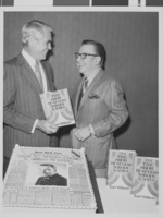
Photograph of Mayor Oran K. Gragson (left) with author Earl Wilson, circa 1971
Date
1969 to 1972
Archival Collection
Description
Las Vegas Mayor Oran K. Gragson (left) with author Earl Wilson. Mayor Gragson is holding a copy of Earl's book, The Show Business Nobody Knows. A large cake decorated as a newspaper announcing the publishing of the book sits on the table in front of them. The location where the photograph was taken is unknown. Oran Kenneth Gragson (February 14, 1911 – October 7, 2002) was an American businessman and politician. He was the longest-serving mayor of Las Vegas, Nevada, from 1959 to 1975. Gragson, a member of the Republican Party, was a small business owner who was elected Mayor on a reform platform against police corruption and for equal opportunity for people of all socio-economic and racial categories. Gragson died in a Las Vegas hospice on October 7, 2002, at the age of 91. The Oran K. Gragson Elementary School located at 555 N. Honolulu Street, Las Vegas, NV 89110 was named in his honor. Earl Wilson (May 3, 1907–January 16, 1987), born Harvey Earl Wilson, was an American journalist, gossip columnist and author, perhaps best known for his nationally syndicated newspaper column, It Happened Last Night. Wilson's column originated from the New York Post and ran from 1942 until 1983. His chronicling of the Broadway theatre scene during the "Golden Age" of show business formed the basis for a book published in 1971, The Show Business Nobody Knows. He signed his columns with the tag line, "That's Earl, brother." His nickname was "Midnight Earl". In later years, the name of his column was changed to Last Night With Earl Wilson. In his final years with the Post, he alternated with the paper's entertainment writer and restaurant critic, Martin Burden, in turning out the column. (Burden, who died in 1993, took over the Last Night column full-time upon Wilson's retirement.) Wilson is also the author of two controversial books, Show Business Laid Bare, and an unauthorized biography of Frank Sinatra, Sinatra – An Unauthorized Biography. The former book is notable for revealing the extramarital affairs of President John F. Kennedy.
Image
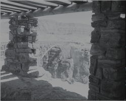
Film transparency of of the Navajo Bridge, Grand Canyon, Arizona, circa 1930s
Date
1930 to 1939
Archival Collection
Description
A view of the Navajo Bridge from inside an adjacent stone building, possibly the Old Cliff Dwellers Lodge (Blanche Russell Rock House), that was built circa 1920. Navajo Bridge crosses the Colorado River's Marble Canyon near Lee's Ferry in Arizona. It carries U.S. Route 89A. Spanning Marble Canyon, the bridge carries U.S. Route 89A northbound travelers to southern Utah and to the Arizona Strip, the otherwise inaccessible portion of Arizona north of the Colorado River, which includes the North Rim of Grand Canyon National Park. Prior to the construction of the first Navajo Bridge, the only river crossing from Arizona to Utah was at nearby Lee's Ferry, where the canyon walls are low and getting vehicles onto the water is relatively convenient. The ferry offered only unreliable service, however, as adverse weather and flooding regularly prevented its operation. Construction of the original Navajo Bridge began in 1927, and the bridge opened to traffic in 1929. The steel spandrel bridge design was constructed by the Kansas City Structural Steel Company. The bridge is 834 feet (254 m) in length, with a maximum height of 467 feet (142 m) from the canyon floor. Its roadway offers an 18-foot (5.5 m) surface width with a load capacity of 22.5 tons (although the posted legal weight limit was 40 tons). In 1990, however, it was decided that the traffic flow was too great for the original bridge, and that a new solution was needed. Deciding on a solution was difficult, due to the many local interests. Issues included preservation of sacred Navajo land, endangered plant species in Marble Canyon, and the possibility of construction pollution entering the river. A new steel arch bridge was commissioned by the Arizona Department of Transportation and the Federal Highway Administration, and was completed in September 1995, at a cost of approximately $15 million. The original Navajo Bridge is still open to pedestrian and equestrian use, and an interpretive center has been constructed nearby to showcase the historical nature of the bridge and early crossing of the Colorado River. Bungee jumpers are frequently seen using the span. The original bridge has been designated as a Historic Civil Engineering Landmark. The bridge was placed on the National Register of Historic Places on August 13, 1981.
Image

Film transparency of Mr. L. J. (Lewis J.) Murphy and the famous Tom Kelly Bottle House in Rhyolite, Nevada, November 25, 1948
Date
1948-11-25
Archival Collection
Description
Mr. L. J. (Lewis J.) Murphy and the famous Tom Kelly Bottle House in Rhyolite, Nevada, which he operated as a free museum in the old ghost town. L. J. Murphy took care of the Bottle House from 1929 until his death in 1953. Two wagon wheels are visible in the front yard. Rhyolite is a ghost town in Nye County, Nevada. It is in the Bullfrog Hills, about 120 miles (190 km) northwest of Las Vegas, near the eastern edge of Death Valley. The town began in early 1905 as one of several mining camps that sprang up after a prospecting discovery in the surrounding hills. During an ensuing gold rush, thousands of gold-seekers, developers, miners and service providers flocked to the Bullfrog Mining District. Many settled in Rhyolite, which lay in a sheltered desert basin near the region's biggest producer, the Montgomery Shoshone Mine. Rhyolite declined almost as rapidly as it rose. After the richest ore was exhausted, production fell. The 1906 San Francisco earthquake and the financial panic of 1907 made it more difficult to raise development capital. In 1908, investors in the Montgomery Shoshone Mine, concerned that it was overvalued, ordered an independent study. When the study's findings proved unfavorable, the company's stock value crashed, further restricting funding. By the end of 1910, the mine was operating at a loss, and it closed in 1911. By this time, many out-of-work miners had moved elsewhere, and Rhyolite's population dropped well below 1,000. By 1920, it was close to zero. After 1920, Rhyolite and its ruins became a tourist attraction and a setting for motion pictures. Most of its buildings crumbled, were salvaged for building materials, or were moved to nearby Beatty or other towns, although the railway depot and a house made chiefly of empty bottles were repaired and preserved. The town is named for rhyolite, an igneous rock composed of light-colored silicates, usually buff to pink and occasionally light gray. It belongs to the same rock class, felsic, as granite but is much less common.
Image
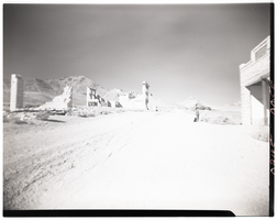
Film transparency of a boy looking at an abandonded building, Rhyolite, Nevada, November 25, 1948
Date
1948-11-25
Archival Collection
Description
A young boy looks at the ruins of the H. D. and L. D. Porter Brothers Store in Rhyolite, Nevada. Several other buildings are visible in the background. Rhyolite is a ghost town in Nye County, Nevada. It is in the Bullfrog Hills, about 120 miles (190 km) northwest of Las Vegas, near the eastern edge of Death Valley. The town began in early 1905 as one of several mining camps that sprang up after a prospecting discovery in the surrounding hills. During an ensuing gold rush, thousands of gold-seekers, developers, miners and service providers flocked to the Bullfrog Mining District. Many settled in Rhyolite, which lay in a sheltered desert basin near the region's biggest producer, the Montgomery Shoshone Mine. Rhyolite declined almost as rapidly as it rose. After the richest ore was exhausted, production fell. The 1906 San Francisco earthquake and the financial panic of 1907 made it more difficult to raise development capital. In 1908, investors in the Montgomery Shoshone Mine, concerned that it was overvalued, ordered an independent study. When the study's findings proved unfavorable, the company's stock value crashed, further restricting funding. By the end of 1910, the mine was operating at a loss, and it closed in 1911. By this time, many out-of-work miners had moved elsewhere, and Rhyolite's population dropped well below 1,000. By 1920, it was close to zero. After 1920, Rhyolite and its ruins became a tourist attraction and a setting for motion pictures. Most of its buildings crumbled, were salvaged for building materials, or were moved to nearby Beatty or other towns, although the railway depot and a house made chiefly of empty bottles were repaired and preserved. The town is named for rhyolite, an igneous rock composed of light-colored silicates, usually buff to pink and occasionally light gray. It belongs to the same rock class, felsic, as granite but is much less common.
Image
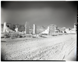
Film transparency of buildings located on Golden Street, Rhyolite, Nevada, November 25, 1948
Date
1948-11-25
Archival Collection
Description
Two buildings that were located on Golden Street in Rhyolite, Nevada. The building on the left was possibly the John T. Overbury building. The building on the right was the John S. Cook & Co. Bank building. Rhyolite is a ghost town in Nye County, Nevada. It is in the Bullfrog Hills, about 120 miles (190 km) northwest of Las Vegas, near the eastern edge of Death Valley. The town began in early 1905 as one of several mining camps that sprang up after a prospecting discovery in the surrounding hills. During an ensuing gold rush, thousands of gold-seekers, developers, miners and service providers flocked to the Bullfrog Mining District. Many settled in Rhyolite, which lay in a sheltered desert basin near the region's biggest producer, the Montgomery Shoshone Mine. Rhyolite declined almost as rapidly as it rose. After the richest ore was exhausted, production fell. The 1906 San Francisco earthquake and the financial panic of 1907 made it more difficult to raise development capital. In 1908, investors in the Montgomery Shoshone Mine, concerned that it was overvalued, ordered an independent study. When the study's findings proved unfavorable, the company's stock value crashed, further restricting funding. By the end of 1910, the mine was operating at a loss, and it closed in 1911. By this time, many out-of-work miners had moved elsewhere, and Rhyolite's population dropped well below 1,000. By 1920, it was close to zero. After 1920, Rhyolite and its ruins became a tourist attraction and a setting for motion pictures. Most of its buildings crumbled, were salvaged for building materials, or were moved to nearby Beatty or other towns, although the railway depot and a house made chiefly of empty bottles were repaired and preserved. The town is named for rhyolite, an igneous rock composed of light-colored silicates, usually buff to pink and occasionally light gray. It belongs to the same rock class, felsic, as granite but is much less common.
Image
Pagination
Refine my results
Content Type
Creator or Contributor
Subject
Archival Collection
Digital Project
Resource Type
Year
Material Type
Place
Language
Records Classification
