Search Results
Wahmonie Cafe, Wahmonie, Nevada: photographic print, approximately 1925 to 1929
Level of Description
Item
Archival Collection
Leon Rockwell Photograph Collection
To request this item in person:
Collection Number: PH-00008
Collection Name: Leon Rockwell Photograph Collection
Box/Folder: Folder 07
Collection Name: Leon Rockwell Photograph Collection
Box/Folder: Folder 07
Archival Component
People camping in Moapa, Nevada: photographic print, approximately 1915 to 1925
Level of Description
Item
Archival Collection
Leon Rockwell Photograph Collection
To request this item in person:
Collection Number: PH-00008
Collection Name: Leon Rockwell Photograph Collection
Box/Folder: Folder 20
Collection Name: Leon Rockwell Photograph Collection
Box/Folder: Folder 20
Archival Component
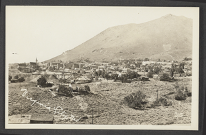
Postcard of Virginia City, Nevada, circa early 1900s
Date
1900 to 1920
Archival Collection
Description
Virginia City, Nevada.
Image
Maps - Filing and proofs of contruction in Dry Valley Branch, Nevada, 1925
Level of Description
File
Archival Collection
Union Pacific Railroad Collection
To request this item in person:
Collection Number: MS-00397
Collection Name: Union Pacific Railroad Collection
Box/Folder: Box 66 (Restrictions apply)
Collection Name: Union Pacific Railroad Collection
Box/Folder: Box 66 (Restrictions apply)
Archival Component

Photograph of Jim Wilson with an unidentified child, Southern Nevada, early 1900's
Date
1900 to 1910
Archival Collection
Description
Jim Wilson with an unidentified child, and their dog Keno in Southern Nevada, early 1900's
Image
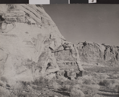
Photograph of Valley of Fire, Nevada, circa early 1900s
Date
1900 to 1939
Archival Collection
Description
The Elephant Rock formation in the Valley of Fire in Nevada.
Image
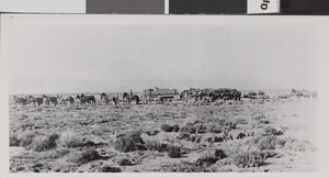
Photograph of wagon train, Nevada, circa early 1900s
Date
1900 to 1939
Archival Collection
Description
A wagon train in the Nevada desert.
Image
Pueblo Grande de Nevada archaeological dig, approximately 1925-1930
Level of Description
File
Archival Collection
Fred and Maurine Wilson Photograph Collection
To request this item in person:
Collection Number: PH-00014
Collection Name: Fred and Maurine Wilson Photograph Collection
Box/Folder: Folder 07 (Restrictions apply)
Collection Name: Fred and Maurine Wilson Photograph Collection
Box/Folder: Folder 07 (Restrictions apply)
Archival Component