Search Results
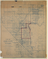
Map of Clark County, Nevada, 1927
Date
1927
Description
'Compiled by J.T. McWilliams from official county records, U.S. Land Dept. surveys, railroad co. field maps and many personal surveys. Made in 1927 by J.T. McWilliams, C.E.' Includes township and road districts, school districts, mining districts, railroads, wagon roads, trails, springs and artesian wells. Scale [ca. 1:316,800. 1 in. to approx. 5 miles] (W 116°--W 114°/N37--N35). Relief shown by hachures. Blueline print. Library's copy 1 has one area outlined by hand in red. Library's copy 2 has school districts outlined in red and green pencil and labeled in pencil by hand.
Image

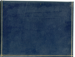
Photograph of University of Nevada, Las Vegas, circa 1980s
Date
1980 to 1989
Archival Collection
Description
Aerial view of a portion of the University of Nevada, Las Vegas (UNLV) campus, looking south. The track is in the foreground, Thomas and Mack Center in the background.
Image
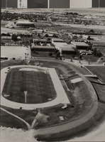
Sun City MacDonald Ranch, Henderson, Nevada: digital photograph
Date
2016-09-14
Archival Collection
Description
Cypress Mesa Drive meanders towards its end in the canyon in the Sun City MacDonald Ranch neighborhood of Henderson, Nevada.
Image

The MGM Grand black jack in Reno, Nevada: postcard
Date
1940 (year approximate) to 1990 (year approximate)
Archival Collection
Description
From the Harvey's Hotel and Casino Postcard Collection (PH-00367) -- MGM Grand Hotel's black jack tables in Reno, Nevada.
Image
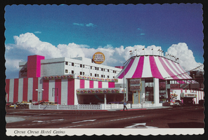
Circus Circus Hotel and Casino in Reno, Nevada: postcard
Date
1979 (year approximate)
Archival Collection
Description
From the Harvey's Hotel and Casino Postcard Collection (PH-00367) -- Circus Circus Hotel and Casino in Reno, Nevada circa 1979
Image

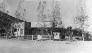
Front of a building in Warm Springs, Nevada: photographic print
Date
1937 to 1938
Archival Collection
Description
From the Nye County, Nevada Photograph Collection (PH-00221) -- Series III. Beatty, Nevada -- Subseries III.B. Lisle Family. A bar stood to the left of the building pictured here, and a school stood to the right, near the present site of the big, stone corral. Mrs. Wilson ran a boarding house in the largest building pictured here.
Image
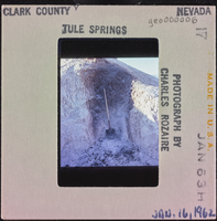
Photographic slide of a shovel, Tule Springs, Nevada, January 1963
Date
1963-01-16
Archival Collection
Description
An upright shovel in Tule Springs, January 16, 1963. Burning to see what, if any, soil changes (e.g. coloring).
Image