Search Results
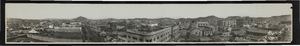
Panoramic view of Goldfield, Nevada: photographic print
Date
1900 (year approximate) to 1910 (year approximate)
Archival Collection
Description
From the Nevada Mining Photograph Collection (PH-00361).
Image
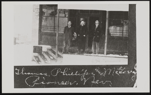
Three men in Pioneer, Nevada: photographic print
Date
1900 to 1940
Archival Collection
Description
Thomas, Phillips, and McGarry standing on a porch in Pioneer, Nevada. A sun shade hangs from above and there are four stairs leading to the porch from left.
Image
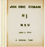
Jon E. Cobain Nevada Southern University graduation scrapbook
Date
1964-06-03
Archival Collection
Description
Jon Eric Cobain's scrapbook with photographs, articles, and items from the June 3, 1964 first graduation of Nevada Southern University (later UNLV).
Mixed Content