Search Results
University of Nevada, Las Vegas (UNLV) Spring 2021 commencement program
Date
Archival Collection
Description
Commencement program from University of Nevada, Las Vegas Commencement Programs and Graduation Lists (UA-00115).
Text
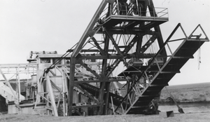
Dredge in Manhattan, Nevada: photographic print
Date
Archival Collection
Description
From the Nye County, Nevada Photograph Collection (PH-00221) -- Series VII. Other areas in Nye County -- Subseries VII.I. Wilson Family (Toiyabe Mountains, Nevada). On the right-hand side of the picture can be seen the pond on which the dredge floated.
Image
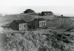
A view of Pioneer, Nevada: photographic print
Date
Archival Collection
Description
From the Nye County, Nevada Photograph Collection (PH-00221) -- Series III. Beatty, Nevada -- Subseries III.G. Reidhead Family. Smoke can be seen rising from the chimney of the large house in the background and both it and the cabin in the foreground on the left appear to be occupied.
Image
University of Nevada, Las Vegas (UNLV) Fall 2021 commencement program
Date
Archival Collection
Description
Commencement program from University of Nevada, Las Vegas Commencement Programs and Graduation Lists (UA-00115).
Text

Topographic map of groundwater in the southeast quadrangle of Las Vegas, Nevada, 1980
Date
Description
Text
Nevada Gaming Commission Nevada Gaming Control Board Listing of Nevada Gaming Licensees expanded version, 1989 November 28
Level of Description
Archival Collection
Collection Name: Gary W. Royer Collection on Gaming
Box/Folder: Box 208 (Restrictions apply)
Archival Component

University of Nevada, Las Vegas (UNLV) 15th commencement program
Date
Archival Collection
Description
Commencement program from University of Nevada, Las Vegas Commencement Programs and Graduation Lists (UA-00115).
Text
Articles of Incorporation of Operation Opportunities - Clark County, Nevada
Date
Archival Collection
Description
From the Clark County Economic Opportunity Board Records (MS-00016) -- Series I. Administrative. "Articles of Incorporation of Operation Opportunities - Clark County, Nevada."
Text
Nevada Gaming Commission Nevada Gaming Control Board Listing of Nevada Gaming Licensees expanded version, 1989 November 28
Level of Description
Archival Collection
Collection Name: Gary W. Royer Collection on Gaming
Box/Folder: Box 211, Box 212 (Restrictions apply)
Archival Component

Holding cells for Nevada Test Site protestors: photographic print
Date
Archival Collection
Description
Image