Search Results
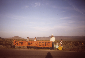
Protesters with big banner at Nevada Test Site, Nevada: photographic slide
Date
1987-04
Archival Collection
Description
From the Sister Klaryta Antoszewska Photograph Collection (PH-00352). Big banner text: “Stop the Tests.” Demonstration at Nevada Test Site.
Image
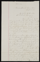
Letter from Mary Etta Syphus, Panaca, Nevada to John M. Bunker, Eldorado Canyon, Nevada
Date
1891-09-21
Archival Collection
Description
From the Syphus-Bunker Papers (MS-00169). The folder contains an original handwritten letter and a typed transcription of the same letter, and a copy of the original letter.
Text
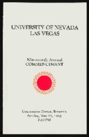
University of Nevada, Las Vegas (UNLV) 19th commencement program
Date
1982-05-23
Archival Collection
Description
Commencement program from University of Nevada, Las Vegas Commencement Programs and Graduation Lists (UA-00115).
Text
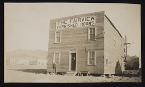
The Fairview, furnished rooms, Seven Troughs mining district, Lovelock, Nevada: photographic print
Date
1906 (year approximate)
Archival Collection
Description
From the Frank Benham Photograph Collection on Goldfield, Nevada (PH-00288). Written on the back of image: "Seven Troughs County Nevada. As the camp of Vernon started up-gold camp. This is out of Lovelock Nevada" - F.H. Benham.
Image
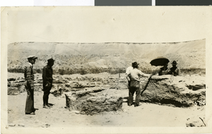
Photograph of Pueblo Grande de Nevada, circa late 1920s
Date
1925 to 1929
Archival Collection
Description
Unidentified archeologists in an excavation site at Pueblo Grande de Nevada, also known as the "Lost City," near Overton, Nevada. Group creators credit goes to John W. Walker Electric Studio in Ely, Nevada.
Image
Nevada and Las Vegas, Nevada maps, 1871 to 2019
Level of Description
File
Archival Collection
Nevada and Las Vegas, Nevada Maps and Tourism Ephemera [UNPROCESSED]
To request this item in person:
Collection Number: MS-01202
Collection Name: Nevada and Las Vegas, Nevada Maps and Tourism Ephemera [UNPROCESSED]
Box/Folder: Box 01, Box 02, Box 03, Box 04, Box 05
Collection Name: Nevada and Las Vegas, Nevada Maps and Tourism Ephemera [UNPROCESSED]
Box/Folder: Box 01, Box 02, Box 03, Box 04, Box 05
Archival Component
Nevada Southern University (University of Nevada, Las Vegas)
Level of Description
File
Archival Collection
Bob Hampton Photographs of Construction Projects in Southern Nevada
To request this item in person:
Collection Number: PH-00362
Collection Name: Bob Hampton Photographs of Construction Projects in Southern Nevada
Box/Folder: N/A
Collection Name: Bob Hampton Photographs of Construction Projects in Southern Nevada
Box/Folder: N/A
Archival Component
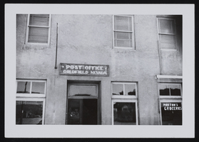
Entrance to new post office, Goldfield, Nevada: photographic print
Date
1947 (year approximate)
Archival Collection
Description
From the Frank Benham Photograph Collection on Goldfield, Nevada (PH-00288).
Image
Nevada State Senate, Carson City, Nevada, 1977
Level of Description
File
Archival Collection
University of Nevada, Las Vegas Photograph Collection
To request this item in person:
Collection Number: PH-00062
Collection Name: University of Nevada, Las Vegas Photograph Collection
Box/Folder: Folder 5
Collection Name: University of Nevada, Las Vegas Photograph Collection
Box/Folder: Folder 5
Archival Component
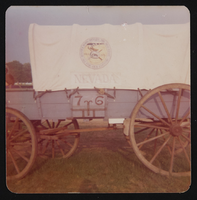
Nevada wagon: photographic print
Date
1976
Archival Collection
Description
From the UNLV Libraries Single Item Accession Photograph Collection (PH-00171). This wagon participated in the Bicentennial celebration at the Valley Forge celebration
Image