Search Results
The "Sunlight" Almanac for 1900. Port Sunlight: Lever Brothers Limited, approximately 1890 to 1899
Level of Description
Item
Archival Collection
Mavis Eggle "Books as They Were Bought" Collection
To request this item in person:
Collection Number: MS-01144
Collection Name: Mavis Eggle "Books as They Were Bought" Collection
Box/Folder: No Container 00
Collection Name: Mavis Eggle "Books as They Were Bought" Collection
Box/Folder: No Container 00
Archival Component
Union Pacific Railroad: contains maps showing the physical city condition of Moapa, Nevada and locations in California such as Long Beach, Ontario, Los Angeles, Riverside, Fullerton, Clayton, Pomona, Wineville, and Hollydale, 1925 July 14-1929 February 21
Level of Description
File
Archival Collection
Union Pacific Railroad Collection
To request this item in person:
Collection Number: MS-00397
Collection Name: Union Pacific Railroad Collection
Box/Folder: Flat File 205 (Restrictions apply)
Collection Name: Union Pacific Railroad Collection
Box/Folder: Flat File 205 (Restrictions apply)
Archival Component
Union Pacific Railroad supporting infrastructure and facilities: contains architectural drawings for a pavillion in Ceder Breaks, Utah, 1924 May 04-1925 July 24
Level of Description
File
Archival Collection
Union Pacific Railroad Collection
To request this item in person:
Collection Number: MS-00397
Collection Name: Union Pacific Railroad Collection
Box/Folder: Flat File 197 (Restrictions apply)
Collection Name: Union Pacific Railroad Collection
Box/Folder: Flat File 197 (Restrictions apply)
Archival Component
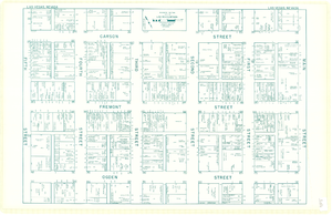
Map of downtown Las Vegas, Nevada, circa 1952-1955
Date
1952 to 1955
Description
Title in upper left and right margins: Las Vegas, Nevada. Identifies business tenants in the downtown area and includes property valuations, measurements, addresses, etc. Cadastral map. Oriented with north to the lower right.Text, illustrations, aerial photos, and ancillary map of the Las Vegas Strip on verso. Cataloger has determined date of map to be between 1952 and 1955 because the Sahara and the Sands Casinos are shown on the verso of the map, and they both opened in 1952, but the Riviera and the Dunes opened in 1955, and they are not shown on the map. Also, the Hotel Last Frontier is shown on the verso of the map, and its name was changed to New Frontier in 1955. Note: Many of the property names and addresses are erroneous when compared to Las Vegas business directories from the same period.
Image
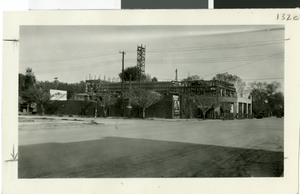
Photograph of El Portal theater under construction on Fremont Street, Las Vegas, circa early 1900s
Date
1905 to 1930
Archival Collection
Description
A view from across the road of the El Portal theater under construction. The Air Dome theater is on the corner.
Image
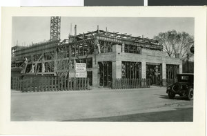
Photograph of El Portal theater under construction on Fremont Street, Las Vegas, circa early 1900s
Date
1905 to 1930
Archival Collection
Description
El Portal theater under construction. Air Dome theater is on the corner of the street, out of frame.
Image
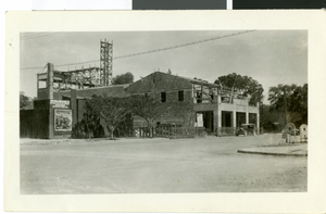
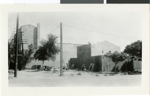
Photograph of El Portal theater under construction on Fremont Street, Las Vegas, circa early 1900s
Date
1905 to 1930
Archival Collection
Description
El Portal theater under construction. Air Dome theater is on the corner of the street, out of frame.
Image
Photograph of El Portal theater under construction on Fremont Street, Las Vegas, circa early 1900s
Date
1905 to 1930
Archival Collection
Description
El Portal theater under construction. Air Dome theater is on the corner of the street, out of frame.
Image
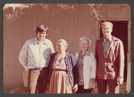
Photograph of Mary Edwards, Elbert Edwards, and others, Taos, New Mexico, circa mid to late 1900s
Date
1950 to 1999
Archival Collection
Description
Mary and Elbert Edwards (right) posing beside two other unidentified individuals in Taos, New Mexico.
Image
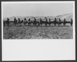
Photograph of Preston Nutter cattle-men on Arizona Strip, Arizona, circa late 1800s - mid 1900s
Date
1870 to 1969
Archival Collection
Description
Description provided with image: "A link between the old West and the new. Preston Nutter cattle-men on the Arizona Strip, the breeding range for the cattle. In the spring steers were shipped to Utah and trailed from the rail head at Colton to the range on the west Tavaputs Plateau."
Image