Search Results
Photographs of early Las Vegas tent camps, wagons, first state bank, and other early permanent structures of Las Vegas; 1900s newspaper; Railroadmen's Ball ticket, 1905-1935
Level of Description
File
Archival Collection
Von Tobel Family Papers
To request this item in person:
Collection Number: MS-00589
Collection Name: Von Tobel Family Papers
Box/Folder: Oversized Box 07
Collection Name: Von Tobel Family Papers
Box/Folder: Oversized Box 07
Archival Component
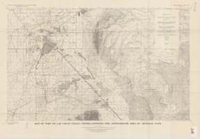
Map of part of Las Vegas Valley, Nevada, showing the approximate area of artesian flow, 1965
Date
1965
Description
At top of map: 'United States Department of the Interior, Geological Survey. Water supply paper 1780, plate 2.' At bottom of map: 'Base from U.S. Geological Survey Las Vegas (1952) and Henderson (1952) quadrangles.' 'Interior--Geological Survey, Washigton, D.C.--1965--W63358.' Relief shown by contours. Includes township and range lines. Thematic map. Scale 1:62,500 (W 115°15´--W 114°45´/N 36°15´--N 36°00´). Series: Water-supply paper (Washington, D.C.)
1780. Originally published as plate 2 of Available water supply of the Las Vegas ground-water basin, Nevada, by Glenn T. Malmberg, published by the Geological Survey in 1965 as its Water-supply paper 1780.
1780. Originally published as plate 2 of Available water supply of the Las Vegas ground-water basin, Nevada, by Glenn T. Malmberg, published by the Geological Survey in 1965 as its Water-supply paper 1780.
Image
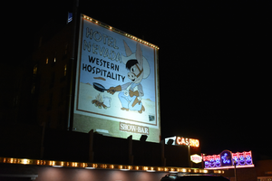
Hotel Nevada billboard, Ely, Nevada
Date
2016 (year approximate) to 2020 (year approximate)
Archival Collection
Description
View of the Hotel Nevada billboard reading "Hotel Nevada Western Hospitality."
501 E Aultman St, Ely, NV 89301
Image
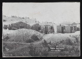
Pioneer buildings, Goldfield, Nevada: postcard
Date
1900 to 1909
Archival Collection
Description
From the Frank Benham Photograph Collection on Goldfield, Nevada (PH-00288).
Image
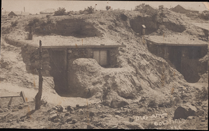
Dugout homes, Goldfield, Nevada: postcard
Date
1900 to 1909
Archival Collection
Description
From the Frank Benham Photograph Collection on Goldfield, Nevada (PH-00288).
Image
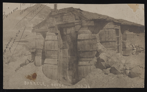
Barrell House, Tonopah, Nevada: postcard
Date
1900 to 1909
Archival Collection
Description
From the Frank Benham Photograph Collection on Goldfield, Nevada (PH-00288).
Image
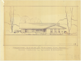
Architectural drawing of residential home in Boulder City, Nevada, preliminary elevation, 1962
Date
1962
Archival Collection
Description
Preliminary drawing of front exterior elevation of ra anch-style residential home in Boulder City, Nevada. Handwritten near lower right: "Elevations only for Plan 1 (1B, 1C, 1D), Plan 2 (2B, 2C, 2D), Plan 4 (4B, 4C, 4D), Plan 5 (5B, 5C, 5D)."
Architecture Period: Mid-Century ModernistImage
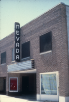
Slide of the Nevada Theater, Wells, Nevada, 1986
Date
1986
Archival Collection
Description
An image of the Nevada Theater located in Wells. The black and white neon sign located above the entrance doors to the building reads: "Nevada." Site Name: Nevada Theater (Wells, Nev.)
Image
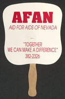
Aid for AIDS of Nevada fan
Date
1990 (year approximate) to 1999 (year approximate)
Archival Collection
Description
From the Dennis McBride Collection on LGBTQ Las Vegas, Nevada (MS-00802) -- Alphabetical research files -- AIDS: Organizations: Aid for AIDS of Nevada (AFAN) file.
Text

Map of the Las Vegas ground-water basin, Clark, Nye, and Lincoln Counties, Nevada, 1965
Date
1965
Description
At top of map: 'United States Department of the Interior, Geological Survey. Water-supply paper 1780, plate 1.' At bottom of map: 'Base from Army Map Service sheets NJ 11-9, NJ 11-12, and NI 11-3 (1947).' 'Boundary between bedrock and alluvium in Clark County, Nev., compiled by Ben Boyer, E. H. Pampeyan and C. R. Longwell. In Lincoln and Nye Counties, contact determined from aerial photographs.' 'Interior--Geological Survey, Washington, D.C.--1965--W63358.' Includes township and range lines.Relief shown by contours. Thematic map. Scale 1:250,000 (W 116°--W 114°45´/N 37°00´--N 35°30´). Series: Water-supply paper (Washington, D.C.), 1780. Originally published as plate 1 of Available water supply of the Las Vegas ground-water basin, Nevada, by Glenn T. Malmberg, published by the Geological Survey in 1965 as its Water-supply paper 1780.
Image