Search Results
West End Borax, Tonopah, Nevada, approximately 1925
Level of Description
File
Archival Collection
Helen J. Stewart Photographs
To request this item in person:
Collection Number: PH-00104
Collection Name: Helen J. Stewart Photographs
Box/Folder: Oversized Box SH-060
Collection Name: Helen J. Stewart Photographs
Box/Folder: Oversized Box SH-060
Archival Component
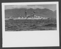
Photograph of U. S. S. Nevada, circa mid 1900s
Date
1930 to 1969
Archival Collection
Description
The U. S. S. Nevada floating in an unidentified body of water.
Image
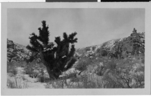
Photograph of the road to Mt. Charleston, Nevada, circa 1925
Date
1925
Archival Collection
Description
The road to Mt. Charleston with views of the desert and a Joshua Tree.
Image
Reno, Nevada, approximately 1900-1910
Level of Description
File
Archival Collection
William V. Wright Collection of Nevada Postcards
To request this item in person:
Collection Number: PH-00094
Collection Name: William V. Wright Collection of Nevada Postcards
Box/Folder: Folder 01
Collection Name: William V. Wright Collection of Nevada Postcards
Box/Folder: Folder 01
Archival Component
Railroad station, Goldfield, Nevada, 1900s
Level of Description
File
Archival Collection
Frank Benham Photograph Collection on Goldfield, Nevada
To request this item in person:
Collection Number: PH-00288
Collection Name: Frank Benham Photograph Collection on Goldfield, Nevada
Box/Folder: Folder 01
Collection Name: Frank Benham Photograph Collection on Goldfield, Nevada
Box/Folder: Folder 01
Archival Component
Ore team, Goldfield, Nevada, 1900s
Level of Description
File
Archival Collection
Frank Benham Photograph Collection on Goldfield, Nevada
To request this item in person:
Collection Number: PH-00288
Collection Name: Frank Benham Photograph Collection on Goldfield, Nevada
Box/Folder: Folder 01
Collection Name: Frank Benham Photograph Collection on Goldfield, Nevada
Box/Folder: Folder 01
Archival Component
Ely, Nevada, approximately 1900-1910
Level of Description
File
Archival Collection
Nevada Mining Photograph Collection
To request this item in person:
Collection Number: PH-00361
Collection Name: Nevada Mining Photograph Collection
Box/Folder: Folder 10 (Restrictions apply)
Collection Name: Nevada Mining Photograph Collection
Box/Folder: Folder 10 (Restrictions apply)
Archival Component
Tonopah, Nevada, approximately 1900-1910
Level of Description
File
Archival Collection
Nevada Mining Photograph Collection
To request this item in person:
Collection Number: PH-00361
Collection Name: Nevada Mining Photograph Collection
Box/Folder: Folder 11 (Restrictions apply)
Collection Name: Nevada Mining Photograph Collection
Box/Folder: Folder 11 (Restrictions apply)
Archival Component
Candelaria, Nevada, approximately 1880-1900
Level of Description
File
Archival Collection
Nevada Historical Society Photograph Collection
To request this item in person:
Collection Number: PH-00033
Collection Name: Nevada Historical Society Photograph Collection
Box/Folder: Folder 01
Collection Name: Nevada Historical Society Photograph Collection
Box/Folder: Folder 01
Archival Component