Search the Special Collections and Archives Portal
Search Results
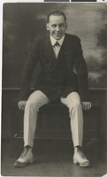
Photograph of Joe Andre, Salt Lake City (Utah), circa 1918
Date
1917 to 1919
Archival Collection
Description
Portrait of Joe Andre in Salt Lake City, Utah.
Image
Clara Bow at 16, after winning the National Fame and Fortune Contest in New York City, New York: photographic print: photographic negative, 1921
Level of Description
Item
Archival Collection
Nan Doughty Photograph Collection
To request this item in person:
Collection Number: PH-00240
Collection Name: Nan Doughty Photograph Collection
Box/Folder: Folder 17
Collection Name: Nan Doughty Photograph Collection
Box/Folder: Folder 17
Archival Component
Hughes Interview B-Roll with New Logo Reveal-Master, undated
Level of Description
File
Archival Collection
Hughes Electronics Corporation Records
To request this item in person:
Collection Number: MS-00485
Collection Name: Hughes Electronics Corporation Records
Box/Folder: Box 14
Collection Name: Hughes Electronics Corporation Records
Box/Folder: Box 14
Archival Component
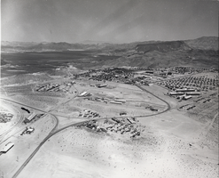
Photograph of Boulder City, Nevada, March 28, 1937
Date
1937-03-28
Archival Collection
Description
The grayscale, aerial view of Boulder City, Nevada. The prominent road of Nevada Way can be seen passing through the little town with the great reservoir of Lake Mead residing in the background.
Image
T-Shirt Color: Navy Blue; Front: The City Of Oklahoma City Fire Dept., City Seal; Back: Oklahoma City Fire Rescue; Handwritten Text: To All The Fallen Heroes - Nick & Keeton 607, approximately 2001-2012
Level of Description
File
Archival Collection
New York-New York Hotel and Casino 9-11 Heroes Tribute Collection
To request this item in person:
Collection Number: MS-00459
Collection Name: New York-New York Hotel and Casino 9-11 Heroes Tribute Collection
Box/Folder: Box 183
Collection Name: New York-New York Hotel and Casino 9-11 Heroes Tribute Collection
Box/Folder: Box 183
Archival Component
Howard Hughes exiting an airplane in New York, 1947 April
Level of Description
File
Archival Collection
Howard Hughes Professional and Aeronautical Photographs
To request this item in person:
Collection Number: PH-00321
Collection Name: Howard Hughes Professional and Aeronautical Photographs
Box/Folder: Folder 12
Collection Name: Howard Hughes Professional and Aeronautical Photographs
Box/Folder: Folder 12
Archival Component
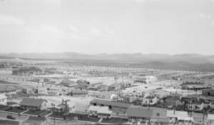
Photograph of Boulder City, Nevada, circa 1933-1934
Date
1932 to 1936
Archival Collection
Description
View of Boulder City, Nevada, showing mostly residential neighborhoods, as well as the Bureau of Reclamation Administration Building (at center left), the Boulder Theatre building on Arizona Street (light-colored building with arches, to the right of the center),and businesses on the Nevada Highway.
Image
Howard Hughes, possibly in an airplane hangar in New York, 1938
Level of Description
File
Archival Collection
Howard Hughes Public Relations Photograph Collection
To request this item in person:
Collection Number: PH-00373
Collection Name: Howard Hughes Public Relations Photograph Collection
Box/Folder: Folder 17
Collection Name: Howard Hughes Public Relations Photograph Collection
Box/Folder: Folder 17
Archival Component
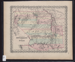
Map showing the territories of New Mexico and Utah, 1855
Date
1855
Description
'Entered according to Act of Congress in the year 1855 by J.H. Colton & Co. in the Clerk's Office of the Dist. Court of the U.S. for the South'n. Dist. of New York.' Scale [ca. 1:4,752,000. 1 in. to approx. 75 miles] (W 120°--W 102°/N 43°--N 32°). Shows natural features, and populated places, wagon route, proposed railroad routes and explorers' routes. Relief shown by hachures. Prime meridians: Greenwich and Washington.Hand colored. Atlas p. number in lower-right margin: 51. Decorative border. J.H. Colton & Co.
Image
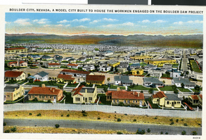
Postcard of Boulder City, circa 1930s-1940s
Date
1930 to 1949
Archival Collection
Description
An artist's color rendering of the Boulder City view towards downtown. Printed text on front of postcard: "Boulder City, Nevada, a model city built to house the workmen engaged on the Boulder Dam project."
Image
Pagination
Refine my results
Content Type
Creator or Contributor
Subject
Archival Collection
Digital Project
Resource Type
Year
Material Type
Place
Language
Records Classification
