Search Results

Theodore Parsons' business card for Ted Parsons Agency Incorporated in Garland, Texas, image 002
Description
Florence-Goldfield Mining Company bills and receipts, 1912 to 1918
Level of Description
Scope and Contents
The Florence-Goldfield Mining Company Series comprises the financial records of the company dating from 1912 to 1918. The series contains primarily bills and receipts associated with purchases from various businesses located in Goldfield and elsewhere including: Nevada-California Power, Al Mills-General Blacksmithing, Wood and Sullivan Hardware, Verdi Lumber Company, Ferry's Transfer Company, and the Union Drayage Company.
Archival Collection
Collection Name: UNLV University Libraries Collection on Nevada Mining
Box/Folder: Box 03
Archival Component
Red Rock Canyon National Conservation Area Records
Identifier
Abstract
The Red Rock Canyon National Conservation records (1965-2007) contain information about the Red Rock Canyon National Conservation Area (previously the Red Rock Canyon Recreation Lands). It largely consists of newspaper clippings on a variety of events related to Red Rock Canyon from 1965 to 1998 with the bulk from the 1980s and 1990s. The records also include Bureau of Land Management documents pertaining to interpretive efforts, visitation statistics, and law enforcement reports. Also included are the newsletters (1990-1998) and volunteer training manual of the Friends of Red Rock Canyon, a non-profit volunteer organization.
Archival Collection

Geologic map of Las Vegas Valley, Nevada, 1982
Date
Description
Image

Surficial geologic map of Las Vegas Valley, Nevada, circa 1981
Date
Description
Image
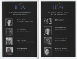
Pamphlet from the 8th annual Jewish Family Service Agency Tsedakah event, 2015
Date
Archival Collection
Description
This pamphlet contains statistics about Jewish Family Service Agency services provided to the community, and sponsorship advertisements from local businesses.
Text
