Search Results


Meeting minutes for Consolidated Student Senate, University of Nevada, Las Vegas, October 12, 1982
Date
Archival Collection
Description
Text
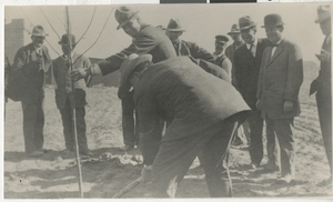
Photograph of people planting first tree in the courthouse park, Las Vegas in March 1911
Date
Archival Collection
Description
Image

Topographic map of groundwater in the southwest quadrangle of Las Vegas, Nevada, 1985
Date
Description
Text
UNLV Libraries Collection of Players International, Inc. Financial and Research Reports
Identifier
Abstract
The UNLV Libraries Collection of Players International, Inc. Financial and Research Reports includes annual reports, financial reports, equity research reports, and prospectus for Players International, Inc. based in Calabasas, California, dating from 1993 to 1998.
Archival Collection
Mollie Gregory Collection of Oral Histories
Identifier
Abstract
The Mollie Gregory Collection of Oral Histories contains audio interviews and brief transcripts that focus on welfare, family, and women's issues in Nevada from 1970 to 1974. Gregory interviewed Nevada residents including Maya Miller, Ruby Duncan, and Mary Wesley, who described their lives during the anti-poverty and women's rights campaigns in the early 1970s. The collection documents views on welfare; the Equal Rights Amendment; race, discrimination, and civil rights; and political campaigns.
Archival Collection
International Food Service Executives Association Records
Identifier
Abstract
The International Food Service Executive Association (IFSEA) Records contain the organizational records from the IFSEA dating from 1916 to 2010. Included are meeting programs and minutes, menus, conference reports and proceedings, financial reports, newsletters, award certificates, scrapbooks, and stewards and caterers records focusing on the hospitality and food service industry. Materials are from both national and regional branches of the organization and include records from the United States military, with whom IFSEA has partnered with since the 1960s. Club artifacts and trophies are also contained in the collection.
Archival Collection