Search Results
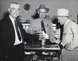
Photograph of Charles F. Peterson and others, Boulder City, Nevada, 1948
Date
1948
Archival Collection
Description
Charles F. Peterson, the Chief Ranger in Boulder City (center), posing beside two other unidentified men in Boulder City, Nevada.
Image
T-Shirt Color: Navy Blue; Front: In Memory Of The Fallen 9-11-2001, Fire Department City Of New York, Police Department City Of New York, Dept. Emblems, Stars And Ribbon; Back: The Other Twin Towers Of New York, They Called We Responded, NYC In Flames And Police And Fire Department In Place Of Towers, approximately 2001-2012
Level of Description
File
Archival Collection
New York-New York Hotel and Casino 9-11 Heroes Tribute Collection
To request this item in person:
Collection Number: MS-00459
Collection Name: New York-New York Hotel and Casino 9-11 Heroes Tribute Collection
Box/Folder: Box 256
Collection Name: New York-New York Hotel and Casino 9-11 Heroes Tribute Collection
Box/Folder: Box 256
Archival Component

Map of California and Territories of New Mexico and Utah, 1862
Date
1862
Description
Scale [ca. 1:3,231,360. 1 in. to approx. 51 miles] (W 125°00--W 103°30/N 42°00--N 31°45) ; 1 map : hand col. ; 40 x 60 cm., on sheet 46 x 68 cm ; Relief indicated by hachures and spot heights ; Prime meridians: Greenwich and Washington, D.C ; Decorative border ; Hand colored ; Atlas p. numbers in upper margin: 58-59 ; Date est. from territorial borders and county configuration ; Shows natural features, locations of Indian tribes, proposed railroad routes, routes of explorers, trails, county boundaries and populated places ; Johnson and Ward
Image
View of George Washington Bridge to the Verazano Bridge in Manhattan from across the Hudson River, New York City, New York: panoramic photograph, 1980 May 28
Level of Description
Item
Archival Collection
Bob Paluzzi Panoramic Photographs
To request this item in person:
Collection Number: PH-00414
Collection Name: Bob Paluzzi Panoramic Photographs
Box/Folder: Box 04, Digital File 00
Collection Name: Bob Paluzzi Panoramic Photographs
Box/Folder: Box 04, Digital File 00
Archival Component

Photograph of a house, Carson City, Nevada, circa 1920s
Date
1920 to 1929
Archival Collection
Description
A woman and a dog outside of a house in Carson City.
Image
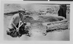
Photograph of a person in Lost City, Nevada, circa early 1900s
Date
1900 to 1930
Archival Collection
Description
An unidentified person in Lost City, Nevada. Description given with photograph says, "Rooms (house 47) Lost City"
Image
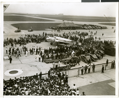
Photograph of the landing of Howard Hughes' Lockheed 14 aircraft, New York, July 14, 1938
Date
1938-07-14
Archival Collection
Description
The black and white view of Howard Hughes' Lockheed 14 aircraft performing its final landing on the Round the World flight at Floyd Bennett Airport, New York. Typed onto a piece of paper attached to the image: "General view of end of the record breaking flight... 7/14/38."
Image
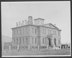
Photograph of Carson City Mint, Nevada, circa 1866
Date
1865 to 1867
Archival Collection
Description
An exterior view of the Carson City Mint, which officially began operations on January 8, 1870 in Carson City, Nevada. It later became the Nevada State Museum, which officially opened on October 31, 1941.
Image