Search Results
T-Shirt Color: Navy Blue; Front: The City Of Oklahoma City Fire Dept., City Seal; Back: Oklahoma City Fire Rescue; Handwritten Text: Station 18, Jacque, approximately 2001-2012
Level of Description
File
Archival Collection
New York-New York Hotel and Casino 9-11 Heroes Tribute Collection
To request this item in person:
Collection Number: MS-00459
Collection Name: New York-New York Hotel and Casino 9-11 Heroes Tribute Collection
Box/Folder: Box 65
Collection Name: New York-New York Hotel and Casino 9-11 Heroes Tribute Collection
Box/Folder: Box 65
Archival Component
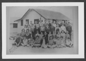
Photograph of students, Boulder City, Nevada, 1932
Date
1932
Archival Collection
Description
Boulder City students.
Image
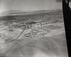
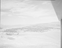
Photograph of Boulder City, Nevada, March 28, 1937
Date
1937-03-28
Archival Collection
Description
The grayscale, aerial view of Boulder City, Nevada. The prominent road of Nevada Way can be seen passing through the little town with the great reservoir of Lake Mead residing in the background. Bits of the actual plane from which the photo was taken can be seen alongside the right border of the image.
Image
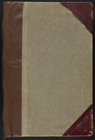
Las Vegas City Ordinances, July 18, 1911 to March 31, 1933
Date
1911-07-18 to 1933-03-31
Archival Collection
Description
Bound volume of Las Vegas City Ordinances, July 18, 1911 to March 31, 1933
Text
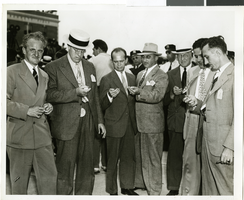
Photograph of a crowd of people awaiting the arrival of Howard Hughes, New York, July 14, 1938
Date
1938-07-14
Archival Collection
Description
The black and white view of members of the Aeronautical Association awaiting the arrival of Howard Hughes and his Lockheed 12 aircraft at the Floyd Bennett Airport in New York. Typed onto a piece of paper attached to the image: "Official timers of Aeronautical Association compare their precision chronometers as Lockheed-14 roars overhead, marking end of Round-the-World flight at Floyd Bennett Airport." Typed onto a second piece of paper also attached to the image: "Official timers of the Aeronautical Association shown at Floyd Bennett Field comparing their precision chronometers as Howard Hughes' plane roared overhead marking the end of his Flight Around The World. July 1938."
Image
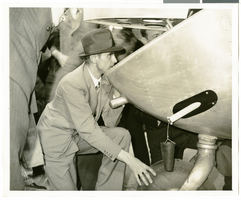
Photograph of Howard Hughes behind his plane at Le Bourget Airfield, France, July 1938
Date
1938-07
Archival Collection
Description
Description printed on photograph's accompanying strip of paper: "Checking damages of plane on arrival at Le Bourget. Le Bourget-- The thoroughness with which he planned the flight and carried it through was still with Howard Hughes when the millionaire flyer and his four companions arrived at Le Bourget, after a record smashing flight across the Atlantic. Hughes is shown here, examining the tail of his plane, just after landing, The tail was damaged slightly. After repairs were made, the fliers took off for Moscow."
Image
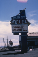
Slide of the Golden City Motel, Nevada, 1986
Date
1986
Archival Collection
Description
Sign advertising the Golden City Motel located on the sign of the Boulder Highway in Nevada. Transcribed onto the sign: "Golden City Motel; Reservations, Kitchenetts, Pool, Color TV, Weekly Spec. Rate." Site Name: Golden City Motel (Las Vegas, Nev.)
Image
Film transparency of Boulder City, Nevada, circa 1931-1936
Date
1931 to 1936
Archival Collection
Description
An image showing an aerial view of Boulder City. The outlines of the small city are distinctively marked by the stark contrast between the city's greenery and the surrounding desert. Bits of the airplane from which the image itself was taken can be seen in the upper right corner of the photograph.
Image
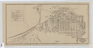
Cadastral map of Boulder City, Nevada, 1940
Date
1905-04-23
Description
A. M. S. Jan. 1940 in the lower left-hand corner. 1 map ; 61 x 30 cm. Cadastral map. "No. 40-1" in the lower right-hand corner. Shows block and lot numbers, buildings, water supply and sewage system, leased areas.
Image