Search Results

Transcript of interview with Miriam "Mimi" Katz by Barbara Tabach, December 10, 2014
Date
Archival Collection
Description
In this interview, Mimi Katz discusses growing up in the Boston area and her schooling, and moving to Washington, D.C. working as a physiotherapist. She returned to Boston and met her husband, and she talks about moving to Las Vegas and adjusting to life here. They became involved at Temple Beth Sholom, and Mimi worked as a conventions coordinator at the Sands and the Sahara. She discusses moving around in Las Vegas from an apartment to a house in the John S. Park neighborhood, working for the Jewish Federation, and helping to develop the Holocaust education program with Edythe Katz, conducting oral history interviews with survivors. She continued working at the Convention Center in the 1980s, and is involved in the Lou Ruvo Center.
Everyone knows her as Mimi. She was born Miriam Green to immigrant parents in Boston, Massachusetts, in 1926. As a youngster she danced, excelled at school and enjoyed an abundance of sports. To pay for her higher education at Massachusetts School of Physiotherapy she worked at Raytheon Manufacturing. In 1957 she married George Katz who swept her away to their honeymoon in Las Vegas. It's a story that she loves to recall-they never left. She sent for her things and energetically settled in to her new hometown and marriage. Mimi found employment with the Clark County School District, began having children (three daughters), and making fast new friends. Many of these friends were from the founding days of Temple Beth Sholom, which roots her to the history of the local Jewish community. In addition, for a decade she worked in community relations for the Jewish Federation. She valued community activism and volunteered over the years for many organizations; such as Easter Seals, Jewish War Veterans, Parent Teachers Association and the Lou Ruvo Center for Brain Health, and many more organizations over the subsequent decades.
Text
Chapter from autobiography by Bella Stern, 1980
Date
Archival Collection
Description
In this chapter, Stern describes her upbringing in Russia and fleeing to Poland. It is accompanied by a letter to the publishing company William Morrow.
Text
Audio recording clip of interview with Faye Duncan Daniel by Claytee D. White, October 18, 1996
Date
Archival Collection
Description
Part of an interview with Faye Duncan Daniel by Claytee White on October 18, 1996. Daniel discusses the Displaced Homemaker Program and Help Centers of Southern Nevada, which resulted in Women of Achievement.
Sound
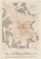
Map and basin profiles showing thickness of valley-fill deposits, Las Vegas Valley, Nevada, 1981 (color variation)
Date
Description
Image
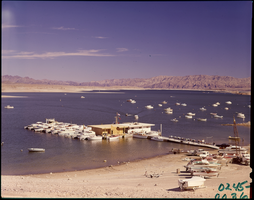
Film transparency of Las Vegas Bay, Lake Mead, Nevada, 1961
Date
Archival Collection
Description
Image

Film transparency of Las Vegas Bay, Lake Mead, Nevada, 1961
Date
Archival Collection
Description
Image

Film transparency of Las Vegas Bay, Lake Mead, Nevada, 1961
Date
Archival Collection
Description
Image