Search the Special Collections and Archives Portal
Search Results
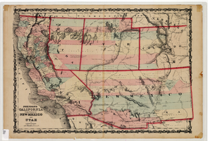
Map of California and territories of New Mexico and Utah, circa 1861
Date
1859 to 1862
Description
'Compiled, drawn, and engraved under the supervision of J.H. Colton and A.J. Johnson.' Relief shown by hachures and spot heights. Scale [ca. 1:3,041,280]. 1 in. to approx. 48 miles (W 124°--W 103°/N 42°--N 31°). Hand colored
Prime meridians: Greenwich and Washington
Plates 54 & 55 removed from Johnson's New illustrated family atlas of the world, with descriptions geographical, statistical and historical ... New York, 1862
Title page of atlas.
Prime meridians: Greenwich and Washington
Plates 54 & 55 removed from Johnson's New illustrated family atlas of the world, with descriptions geographical, statistical and historical ... New York, 1862
Title page of atlas.
Image
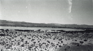
Photograph of the Lost City site and Lake Mead, near Overton, Nevada, spring 1938
Date
1938
Archival Collection
Description
Long shot of the Lost City site (Pueblo Grande de Nevada), near Overton, Nevada, with the northwest arm of Lake Mead in the distance. The area is near the ruins of St. Thomas, Nevada, another nearby extinct town, submerged by Lake Mead.
Image
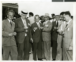
Photograph of a crowd of people awaiting the arrival of Howard Hughes, New York, July 14, 1938
Date
1938-07-14
Archival Collection
Description
The black and white view of members of the Aeronautical Association awaiting the arrival of Howard Hughes and his Lockheed 12 aircraft at the Floyd Bennett Airport in New York. Typed onto a piece of paper attached to the image: "Official timers of Aeronautical Association compare their precision chronometers as Lockheed-14 roars overhead, marking end of Round-the-World flight at Floyd Bennett Airport." Typed onto a second piece of paper also attached to the image: "Official timers of the Aeronautical Association shown at Floyd Bennett Field comparing their precision chronometers as Howard Hughes' plane roared overhead marking the end of his Flight Around The World. July 1938."
Image
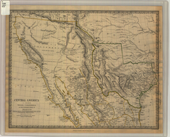
Map of Texas, California, New Mexico and the northern states of Mexico, October 15, 1842
Date
1842-10-15
Description
'Published under the superintendence of the Society for Diffusion of Useful Knowledge.' 'Published by Chapman & Hall, 186 Strand, 15 Oct. 1842.' 'J. & C. Walker, Sculpt.' Scale [ca. 1:7,600,000]. 1 in. to ca. 120 miles (W 125°--W 91°/N 43°--N 23° 30?). 1 map ; 31 x 39 cm. Relief indicated by hachures and spot heights. Shows elevations in yards. Includes notes on exploring expeditions, etc. Borders hand colored. Chapman & Hall.
Image
New York Mine, Silver City, Nevada
Level of Description
File
Archival Collection
Mary Griffith Toleno Photograph Collection
To request this item in person:
Collection Number: PH-00021
Collection Name: Mary Griffith Toleno Photograph Collection
Box/Folder: N/A
Collection Name: Mary Griffith Toleno Photograph Collection
Box/Folder: N/A
Archival Component
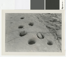
Photograph of a grinding slab metate at the Lost City, Clark County, before 1938
Date
1930 to 1938
Archival Collection
Description
Grinding slab metate at the Lost City with numerous holes
Transcribed Notes: Notes on photo sleeve Los City, Nevada. Holes and stones were used to grind grains, etc. (Credit: W.A. Davis); 'Gypsum Cave, bedrock mortars near cave' - W.A. Davis
Image
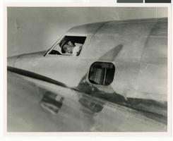
Photograph of Howard Hughes in the cockpit of a Lockheed-14 plane, New York, July 10, 1938
Date
1938-07-10
Archival Collection
Description
Howard Hughes in cockpit of Lockheed-14 before take-off from Floyd Bennet Field in New York.
Image
New Jersey: Atlantic City, 1989 to 1995
Level of Description
File
Archival Collection
UNLV Libraries Collection of Regional History Files
To request this item in person:
Collection Number: MS-00547
Collection Name: UNLV Libraries Collection of Regional History Files
Box/Folder: Box 27
Collection Name: UNLV Libraries Collection of Regional History Files
Box/Folder: Box 27
Archival Component
North Las Vegas and City Hall construction, 1940s-1960s
Level of Description
File
Archival Collection
North Las Vegas Library District Collection on Nevada
To request this item in person:
Collection Number: MS-00651
Collection Name: North Las Vegas Library District Collection on Nevada
Box/Folder: Box 12
Collection Name: North Las Vegas Library District Collection on Nevada
Box/Folder: Box 12
Archival Component
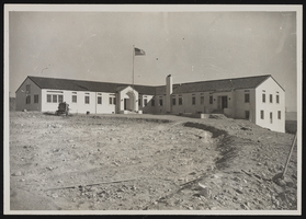
Photograph of a museum building, Boulder City (Nev.), January 10, 1938
Date
1938-01-10
Archival Collection
Description
Museum and Administration Building stands in a vacant dirt field. An American flag waves in front of the structure.
Image
Pagination
Refine my results
Content Type
Creator or Contributor
Subject
Archival Collection
Digital Project
Resource Type
Year
Material Type
Place
Language
Records Classification
