Search Results
Meeting minutes for Consolidated Student Senate University of Nevada, Las Vegas, April 26, 1999
Date
Archival Collection
Description
Text

Meeting minutes for Consolidated Student Senate, University of Nevada, Las Vegas, February 02, 2004
Date
Archival Collection
Description
Text
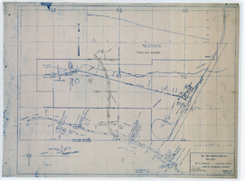
Map showing location of 24" C.I. pipeline in Las Vegas, Nevada, circa 1943
Date
Archival Collection
Description
Image
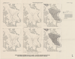
Maps showing distribution of coarse- and fine-grained deposits in the upper 1,000 feet of valley fill, Las Vegas Valley, Nevada, 1981 (Water-supply paper 2320-A, plate 3)
Date
Description
Image
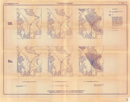
Maps showing distribution of coarse- and fine-grained deposits in the upper 1,000 feet of valley fill, Las Vegas Valley, Nevada, 1981 (Open-file report 84-130, plate 3)
Date
Description
Image
Map of explorations and surveys south of the Central Pacific Railroad made by the U.S. Army Corps of Topographical Engineers, 1871
Date
Description
Image

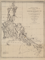
Map showing detailed topography of the country traversed by the reconnaissance expedition through southern & southeastern Nevada, 1869
Date
Description
Image

Map showing detailed topography of the country traversed by the reconnaissance expedition through southern & southeastern Nevada, 1869 (reproduction)
Date
Description
Image
David Coons Photograph Collection
Identifier
Abstract
The David Coons Photograph Collection contains photographs and postcards depicting railroads in Nevada, California, and Utah from 1907 to 1956. The photographs depict trains and locomotives from the Tonopah & Tidewater Railroad, Union Pacific Railroad, San Pedro, Los Angeles & Salt Lake City Railroad, Bullfrog-Goldfield Railroad, Las Vegas & Tonopah Railroad, and Tonopah & Goldfield Railroad. The photographs also portray Arden, Nevada and the Arden Plaster Company Plant, Las Vegas High School after a fire, and early Fremont Street in Las Vegas, Nevada.
Archival Collection