Search Results
North Las Vegas Libriary under construction and City Hall, Civic Center Drive, 1965
Level of Description
File
Archival Collection
North Las Vegas Library Photograph Collection on North Las Vegas, Nevada
To request this item in person:
Collection Number: PH-00277
Collection Name: North Las Vegas Library Photograph Collection on North Las Vegas, Nevada
Box/Folder: Folder 04
Collection Name: North Las Vegas Library Photograph Collection on North Las Vegas, Nevada
Box/Folder: Folder 04
Archival Component
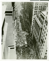
Photograph of a parade for Howard Hughes, New York City, July 15, 1938
Date
1938-07-15
Archival Collection
Description
Typed onto a piece of paper attached to the image: "New York Acclaims World Fliers, New York City --- Looking up Broadway during the ticker-tape reception accorded Howard Hughes and his four companions in recognition of their Round-The-World record-smashing flight. The dense crowd which lined both sides of the through fare has closed in behind the parade, while further ahead fresh showers of torn paper flutter down on the motorcade. 7(3/4)-15-38. Credit Line (ACME)."
Image
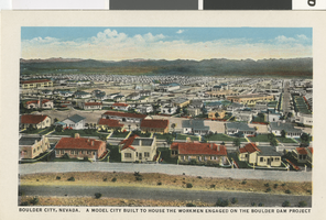
Postcard of Boulder City (Nev), 1931
Date
1931
Archival Collection
Description
Illustration of Boulder City, in which many houses and neighborhoods can be seen. The caption reads: "Boulder City, Nevada. A model city built to house the workmen engaged on the Boulder Dam [later known as the Hoover Dam] Project."
Image
North Las Vegas Libriary under construction and City Hall, Civic Center Drive, 1965
Level of Description
File
Archival Collection
North Las Vegas Library Photograph Collection on North Las Vegas, Nevada
To request this item in person:
Collection Number: PH-00277
Collection Name: North Las Vegas Library Photograph Collection on North Las Vegas, Nevada
Box/Folder: Folder 04
Collection Name: North Las Vegas Library Photograph Collection on North Las Vegas, Nevada
Box/Folder: Folder 04
Archival Component