Search Results
Construction continues on the UNLV Mendenhall Basketball practice facility July 15, 2011 at the University of Nevada, Las Vegas: digital photographs
Date
2011-07-15
Archival Collection
Description
Photographs from the University of Nevada, Las Vegas Creative Services Records (2010s) (PH-00388-05).
Image
Meras, Phyllis. I was afraid to say I wanted to see Sin City (Innocence in Las Vegas), Providence Journal, 1992 July 12
Level of Description
File
Archival Collection
UNLV Libraries Collection of Articles on Gaming and Las Vegas, Nevada Topics
To request this item in person:
Collection Number: MS-00626
Collection Name: UNLV Libraries Collection of Articles on Gaming and Las Vegas, Nevada Topics
Box/Folder: Box 18
Collection Name: UNLV Libraries Collection of Articles on Gaming and Las Vegas, Nevada Topics
Box/Folder: Box 18
Archival Component
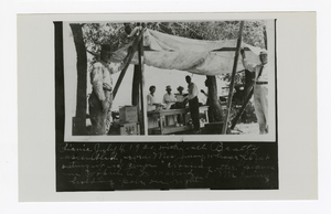
Photograph of town picnic, Beatty (Nev.), July 4, 1920
Date
1920-07-04
Archival Collection
Description
Caption: Picnic July 4, 1920 with all Beatty assembled.
Image

Frank Hawkins city council candidacy rally, Culinary Union, Las Vegas (Nev.), 1990s (folder 1 of 1), image 15
Date
1990 to 1999
Description
Arrangement note: Series II. Public Events
Image

Conversations in the City: The City and Sex, 2005
Level of Description
File
Archival Collection
Guide to the Canadian Film Centre Worldwide Short Film Festival Submissions
To request this item in person:
Collection Number: MS-00615
Collection Name: Guide to the Canadian Film Centre Worldwide Short Film Festival Submissions
Box/Folder: Box 2005-034
Collection Name: Guide to the Canadian Film Centre Worldwide Short Film Festival Submissions
Box/Folder: Box 2005-034
Archival Component
Carolyn Levering (City of Las Vegas, Emergency Manager) oral history interview conducted by Kelliann Beavers, 2022 July 28
Level of Description
Item
Archival Collection
Lincy Institute "Perspectives from the COVID-19 Pandemic" Oral History Project
To request this item in person:
Collection Number: MS-01178
Collection Name: Lincy Institute "Perspectives from the COVID-19 Pandemic" Oral History Project
Box/Folder: Digital File 00
Collection Name: Lincy Institute "Perspectives from the COVID-19 Pandemic" Oral History Project
Box/Folder: Digital File 00
Archival Component
EPA "208" Interim Progress Report; Planning Program by Multiple Authors, approximately 1976 July 15 to 1979 January 13
Level of Description
File
Archival Collection
Clark County Planning Commission Research Library Collection
To request this item in person:
Collection Number: MS-01027
Collection Name: Clark County Planning Commission Research Library Collection
Box/Folder: Box 27
Collection Name: Clark County Planning Commission Research Library Collection
Box/Folder: Box 27
Archival Component
In the City
Level of Description
File
Archival Collection
Guide to the Canadian Film Centre Worldwide Short Film Festival Submissions
To request this item in person:
Collection Number: MS-00615
Collection Name: Guide to the Canadian Film Centre Worldwide Short Film Festival Submissions
Box/Folder: Box 2006-010
Collection Name: Guide to the Canadian Film Centre Worldwide Short Film Festival Submissions
Box/Folder: Box 2006-010
Archival Component