Search Results

Interview with Troy Ernest Wade II, June 16, 2004
Date
Archival Collection
Description
Text
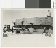
Photograph of water storage tank construction in Boulder City, circa 1931
Date
Archival Collection
Description
Construction of a water tank in Boulder City by the Clearfire Water Company.
Transcribed Notes: Notes on photo sleeve: 'Hill leveled with dynamite before building tank - Clearfire Water Co. Water came into booster plant from river. Dumps at river were on inclined steel rails and went up and down with water level. Then went from booster plant to clarification station, then on to this storage tank.' (W.A. Davis)
Image
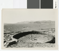
Photograph of settling basin at the head of Hemenway Wash for water purification works in Boulder City, circa 1931
Date
Archival Collection
Description
Settling basin at the head of Hemenway Wash for water purification works in Boulder City.
Transcribed Notes: Stamped on back of photo: Photograph by W. A. Davis Box 1169, Las Vegas, Nevada; Notes on photo sleeve: [Setting basin for making concrete. Upstream from the Dam about 5-10 miles. R.R. track may have crossed over to Arizona.] Photographer W.A. Davis disagrees: says this is part of a water purification plant; the settling basin shown purifies water. (documentation, 4/92)
Image
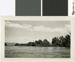
Photograph of Tamarisk trees sticking out of the water in St. Thomas, Nevada, circa June, 1938
Date
Archival Collection
Description
The tops of tamerisk trees show above the water line of Lake Mead at St. Thomas, Nevada.
Transcribed Notes: Transcribed from photo sleeve: "What was once the main throughfare and entrance to the prosperous little Mormon town of St. Thomas now shows only the tops of the tamarix (sic) trees which lined its irrigation ditches. (phto by E. Edwards)"
Image
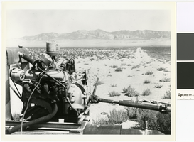
Photograph of a butane powered pump engine on the T & T Ranch, Nevada, circa 1958
Date
Archival Collection
Description
Since the Amargosa Valley did not have electricity until 1964, all pumps were run by combustion engines, like this one on the T & T Ranch.
Transcribed Notes: Transcribed from photo sleeve: "Land on the T & T Ranch, Amargosa Valley, Nye County, Nevada, about 1958 or 1959. Commercial electricity was not available in the Amargosa Valley until 1964. Until then all water pumping was done with combustion engines running at the wells. Pictured here is a butane-operated motor, running a pump on the property belonging to Hank Records."
Image
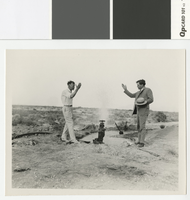
Photograph of Fred Hesse and Fred Balzar opening an artesian well in Las Vegas, circa 1930
Date
Archival Collection
Description
Las Vegas mayor J. Fred Hesse (left) and Nevada governor Fred Balzar (right) at opening of an artesian well in Las Vegas
Transcribed Notes: Notes on photo sleeve: "Las Vegas Mayor J. Fred Hesse (left) and Nev. Governor Fred Balzar at opening of an artesian well in Las Vegas, ca. 1929-32"; Stamped on back of photo: G. L. Ullom. 104 Fremont Street. Las Vegas, Nevada
Image
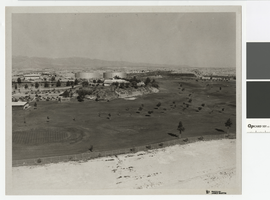
Photograph of North Las Vegas golf course, northwest direction, circa 1965
Date
Archival Collection
Description
North Las Vegas golf course with Parks and Recreation Building and city water tanks.
Transcribed Notes: Notes from photo sleeve: "North Las Vegas Golf Course (Par 3) with Parks and Recreation Building and city water storage tanks"; Notes on back: "NLV Par 3 Golf Course with P & R Bldg. and city water storage tanks."
Image
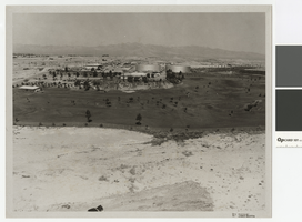
Photograph of North Las Vegas golf course, westward direction, circa 1965
Date
Archival Collection
Description
North Las Vegas golf course with Parks and Recreation Building and city water tanks.
Transcribed Notes: Notes from photo sleeve: "North Las Vegas Golf Course (Par 3) with Parks and Recreation Building and city water storage tanks"; Notes on back: "NLV Par 3 Golf Course with P & R Bldg. and city water storage tanks."
Image
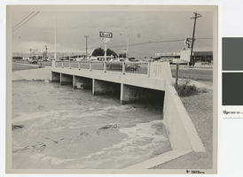
Photograph of water running high in flood channel and North Las Vegas Boulevard flood channel
Date
Archival Collection
Description
Flood channel with water running high under North Las Vegas Boulevard. Signs on front for 91 and 93 freeways
Transcribed Notes: Notes from photo sleeve: "Las Vegas Boulevard North and North Las Vegas flood channel, ca. 1970s." Notes on back: "Las Vegas Blvd North and NLV flood channel."
Image
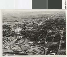
Aerial photograph of Las Vegas in the mid to late 1930s
Date
Archival Collection
Description
Aerial photo of Las Vegas looking south.
Transcribed Notes: Transcribed from photo sleeve: "[L. Foreground, old city hall. R. foreground, post office. Circular Park w/Boy scout structures (7)] "Aerial view of Las Vegas shows old park with race track (about where municipal swimming pool is) Small huts in group were Boy Scout huts made of stone. Scout troups met here surrounded by park taken middle or late 30's."- Dave Coons"
Image