Search the Special Collections and Archives Portal
Search Results
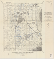
Map of part of Las Vegas Valley, Nevada, showing the approximate piezometric surface in 1912
Date
1965
Description
'Base by U.S. Geological Survey, 1952.' 'Interior--Geological Survey, Washington, D.C.--1965--W63358.' 'Compiled from data published by Carpenter (1915), Kearney (1913), and McWilliams (1913).' Relief shown by contours. Includes township and range lines. Scale 1:62,500 (W 115°15´--W 115°00´/N 36°15´--N 36°00´). Series: Water-supply paper (Washington, D.C.)
1780. Originally published as plate 7 of Available water supply of the Las Vegas ground-water basin, Nevada, by Glenn T. Malmberg, published by the Geological Survey in 1965 as its Water-supply paper 1780.
1780. Originally published as plate 7 of Available water supply of the Las Vegas ground-water basin, Nevada, by Glenn T. Malmberg, published by the Geological Survey in 1965 as its Water-supply paper 1780.
Image

Photograph of the bridge over Las Vegas Creek, circa 1905
Date
1905 (year approximate)
Archival Collection
Description
Bridge over Las Vegas Creek.
Transcribed Notes: Transcribed from back of photo: "This was east of the house we lived in. M. C."
Image
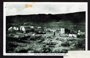
Postcard of a Goldfield mining camp, Goldfield (Nev.), 1903
Date
1903
Archival Collection
Description
Caption: Early Days of Goldfield, Nevada, November 1903
Image
Pagination
Refine my results
Content Type
Creator or Contributor
Subject
Archival Collection
Digital Project
Resource Type
Year
Material Type
Place
Language
Records Classification


