Search Results
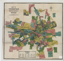
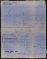
Map of the Tonopah Mining District, Nye County (Nev.), 1905
Date
1905
Description
Scale [ca. 1:15,600. 1 in. to approx. 1300 feet] ; 1 map : col. ; 60 x 64 cm ; Relief shown by hachures ; Copyright held by Bradford & Bradford ; Includes table of distances ; Library's copy has one section outlined in red pencil and Tonopah Victor printed on it in red pencil. Red pencil dots are on two other sections. 1905 printed in pencil and some unreadable words written in pencil near title of map ;
Image
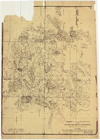
Map of approved mineral surveys in the Goldfield Mining District, Goldfield (Nev.), 1908
Date
1908
Description
Scale [ca. 1:9,600]. 1 in. to 800 feet. (W 117 14'--W 117 09'/N 37 46'--N 37 41') ; 1 map ; 129 x 97 cm ; Blueline print ; Includes township and range grid ; "Copyright 1908 by Davis and Byler. 1911." ; Library's copy has upper-left corner torn off and has circles drawn around and diagonal lines drawn on certain claims ;
Image
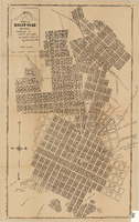
Map of Goldfield (Nev.), 1907
Date
1907
Description
Scale: [ca. 1:4,800] 1 inch = 400 ft ; 1 map ; 66 x 39 cm ; Plat map ; "April 25, 1907." ; Library's copy has notes handwritten in pencil along right margin with arrows to locations on map: "Ramsey Street ended Columbia St." "MacMaskrs office." "Lived on Euclid ave in adobe house." " Lived in Tent House Sundog Ave." ;
Image