Search Results
Map of explorations and surveys south of the Central Pacific Railroad made by the U.S. Army Corps of Topographical Engineers, 1871
Date
Description
Image

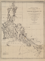
Map showing detailed topography of the country traversed by the reconnaissance expedition through southern & southeastern Nevada, 1869
Date
Description
Image

Map showing detailed topography of the country traversed by the reconnaissance expedition through southern & southeastern Nevada, 1869 (reproduction)
Date
Description
Image
McNamee Family Papers
Identifier
Abstract
The McNamee Family Papers (approximately 1898-2000) are comprised of family papers of early Nevada settlers, Frank (Francis) Raphael McNamee and Effie Alice Webster McNamee. It contains original family photographs and some documents such as newspaper clippings, award certificates, handwritten deeds, and correspondence about Effie and Frank McNamee Sr., and their eight children, including Frank Jr. and Leo McNamee. There are large folders of photocopied genealogy printouts from Ancestry.com regarding Frank and Effie McNamee.
Archival Collection
Nevada Southern Campus Fund Collection
Identifier
Abstract
The Nevada Southern Campus Fund Collection (1955) consists of the Nevada Southern University Book of Donors. This oversized scrapbook contains the names of local businesses, politicians, and Las Vegans who donated over $50 to the Nevada Southern Campus Fund in 1955. Nevada Southern University later became the University of Nevada, Las Vegas (UNLV). Some names include Elks Lodge, Rotary Club of Las Vegas, and Junior League of Las Vegas.
Archival Collection
Stan Armstrong Photograph Collection [DEACCESSIONED]
Identifier
Abstract
[DEACCESSIONED] Collection is comprised of personal and community photos collected by Stan Armstrong dating from the 1940s to the 2000s. The collection also consists of photos of the historic Westside neighborhood of Las Vegas, Nevada and its African American community. Also included are promotional posters from Stan Armstrong's documentaries and memorial service programs of members of the African American Community.
Archival Collection
Nevada Division of State Parks Records
Identifier
Abstract
The Nevada Division of State Parks Records consist of materials produced or collected between 1863 and 1978 by the Nevada Division of State Parks. The collection includes materials recovered at Spring Mountain Ranch belonging to the Kiel, George, and Wilson families. The majority of the collection consists of administrative records and correspondence from the Nevada Division of State Parks. It also contains a photograph album of images taken during excavation efforts at the Pueblo Grande de Nevada archaeological site.
Archival Collection
Clark County, Nevada United States Bicentennial Collection
Identifier
Abstract
The Clark County, Nevada United States Bicentennial collection dates from approximately 1970 to 1976. The collection documents Nevada's participation in the 1976 Bicentennial celebration of the American Revolution, as well as celebrations from other states and countries in Europe. The collection is comprised of official reports from the U.S. Bicentennial committee, scrapbooks from the Clark County bicentennial committee, newspapers, and event programs from bicentennial celebrations around the country. The collection also contains a film of various American states' bicentennial celebrations.
Archival Collection
David Coons Photograph Collection
Identifier
Abstract
The David Coons Photograph Collection contains photographs and postcards depicting railroads in Nevada, California, and Utah from 1907 to 1956. The photographs depict trains and locomotives from the Tonopah & Tidewater Railroad, Union Pacific Railroad, San Pedro, Los Angeles & Salt Lake City Railroad, Bullfrog-Goldfield Railroad, Las Vegas & Tonopah Railroad, and Tonopah & Goldfield Railroad. The photographs also portray Arden, Nevada and the Arden Plaster Company Plant, Las Vegas High School after a fire, and early Fremont Street in Las Vegas, Nevada.
Archival Collection