Search Results

Street map of the city of Las Vegas & vicinity, showing streets, main roads and recreation areas, 1954
Date
1954
Description
7 maps on 3 sheets, 2 leaves ; 21 x 31 cm. or smaller on sheets 22 x 35 cm. folded to 22 x 13 cm. in paper cover. Title from cover. Copyright held by James E. Stringer. 1st ed. Includes maps of North Las Vegas, the Strip and Vegas Heights and Meadow Acres. Includes key to map coordinates. Includes index. "Map of Las Vegas & Vicinity showing streets, main roads, and recreation areas." Original publisher: R.W. Baldwin.
Image
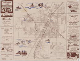
Map of the city of Las Vegas, North Las Vegas, and the "Strip", 1956
Date
1956
Description
40 x 37 cm., folded to 28 x 15 cm. Copyright held by Robert E. Barringer. Panel title: Welcome map, greater Las Vegas area and scenic routes to and from there. Includes inset map of Boulder City. Map of California from San Francisco to Los Angeles to Las Vegas by Beth Bergh on verso. Includes notes. Index on verso. Includes advertisements for Las Vegas and California businesses. Original publisher: Redwood Publishing Co..
Image
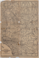
Map of a portion of southern California and southwestern Nevada embracing the arid region of Mojave & Colorado Deserts including Death Valley, circa 1936
Date
1934 to 1938
Description
78 x 52 cm. Relief shown by hachures and spot heights. Panel title: Road map of the Mojave and Colorado Deserts including Death Valley National Monument. In lower right-hand corner: 1379. In lower left-hand corner: Burke-Douglas. Indexes on verso to cities, towns, stations, junctions, resorts and natural features. On verso: Map showing roads and points of interest in Death Valley & vicinity. Originally folded to 27 x 11 cm. Original publisher: The Club.
Image


Geologic map of the Plutonium Valley quadrangle, Nye and Lincoln counties, Nevada, 1965
Date
1965
Description
58 x 46 cm., on sheet 77 x 83 cm., folded in envelope 30 x 24 cm. Relief shown by contours and spot heights. "Geology mapped in 1961." Includes description of map units, col. cross section, and quadrangle location map. "Prepared in cooperation with the U. S. Atomic Commission." Original publisher: Interior, Geological Survey, Series: Geologic quadrangle map GQ, Scale: 1:24 000.
Image

Geology of the Jackass Flats quadrangle, Nye County, Nevada, 1964
Date
1964
Description
58 x 47 cm., on sheet 86 x 81 cm., folded in envelope 30 x 24 cm. Relief shown by contours and spot heights. "Geology mapped in 1961." Includes description of map units, 2 col. cross sections, and quadrangle location map. "Prepared in cooperation with the U. S. Atomic Commission." Original publisher: Interior, Geological Survey, Series: Geologic quadrangle map GQ, Scale: 1:24 000.
Image
Map of a portion of southern California and southwestern Nevada embracing the arid region of Mojave & Colorado Deserts including Death Valley, circa 1937
Date
1937 (year approximate)
Description
79 x 52 cm. Panel title: Road map of the Mojave and Colorado Deserts including Death Valley National Monument. Index on verso. Relief shown by hachures and spot heights. In lower right-hand corner: Burke Douglas Pflum. "3712."--Lower left-hand corner of copy 1. "C13247."--Lower left-hand corner of copy 2. "1379."--Lower right-hand corner. Originally folded to 28 x 11 cm. On verso: Map showing roads and points of interest in Death Valley and vicinity. Original publisher: The Club.
Image