Search Results
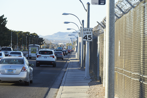
Traffic flows on Eastern Avenue next to the McCarran International Airport fence as seen from Eastern Avenue and Patrick Lane, looking south-southwest in Las Vegas, Nevada: digital photograph
Date
Archival Collection
Description
From the UNLV University Libraries Photographs of the Development of the Las Vegas Valley, Nevada (PH-00394). Part of the collection documents the entire 19 mile length of the north/south Eastern Avenue / Civic Center Drive alignment. This photograph was captured in the section of Eastern Avenue between Russell and Sunset Roads.
Image
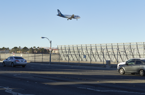
An airplane approaches McCarran International Airport over Eastern Avenue near Sunset Road, looking south-southwest in Las Vegas, Nevada: digital photograph
Date
Archival Collection
Description
From the UNLV University Libraries Photographs of the Development of the Las Vegas Valley, Nevada (PH-00394). Part of the collection documents the entire 19 mile length of the north/south Eastern Avenue / Civic Center Drive alignment. This photograph was captured in the section of Eastern Avenue between Russell and Sunset Roads.
Image
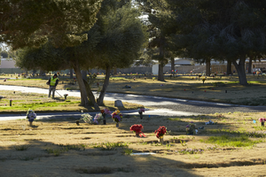
A man trims grass at the Davis Funeral Home and Memorial Park on Eastern Avenue south of Patrick Lane, looking east-southeast in Las Vegas, Nevada: digital photograph
Date
Archival Collection
Description
From the UNLV University Libraries Photographs of the Development of the Las Vegas Valley, Nevada (PH-00394). Part of the collection documents the entire 19 mile length of the north/south Eastern Avenue / Civic Center Drive alignment. This photograph was captured in the section of Eastern Avenue between Russell and Sunset Roads.
Image
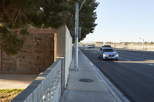
Cars travel past the Davis Funeral Home and Memorial Park on Eastern Avenue south of Patrick Lane, looking south in Las Vegas, Nevada: digital photograph
Date
Archival Collection
Description
From the UNLV University Libraries Photographs of the Development of the Las Vegas Valley, Nevada (PH-00394). Part of the collection documents the entire 19 mile length of the north/south Eastern Avenue / Civic Center Drive alignment. This photograph was captured in the section of Eastern Avenue between Russell and Sunset Roads.
Image
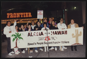
Photographs of Frontier Strike: Desert Solidarity, Solidarity March, Culinary Union, Las Vegas (Nev.), 1990 December 05 (folder 2 of 2)
Date
Archival Collection
Description
Several organizations unite in solidarity to support the Frontier Strike in December 1990. Supporters holding signs, banners, and flags march and pose outside the Frontier. There are also photos of police officers and firemen outside the hotel. Culinary Union secretary-treasurer Jim Arnold is in multiple photos, posing with groups and individuals, shown on stage at a rally, and at a Christmas party. Also included in this folder are: photos of Frontier owners Margaret and Tom Elardi, a portable bathroom decorated with signs and a large rodent, and a clip from an article stating, "DESERT SOLIDARITY, OUR LINE IN THE SAND." Banners and signs in the photos read: "Aloha from Hawaii, local 5 here, Hawaii's people support Frontier Strike," "Frontier Hotel, on strike, Culinary Workers Union, Bartenders Union, Teamsters Union, Operating Engineers Union, Carpenters Union," "AFL-CIO Desert Solidarity," "We're here! Steelworkers district 39 sub-district 2," "Frontier unfair to Teamsters Local Union 995."Arrangement note: Series I. Demonstrations, Subseries I.A. Frontier Strike Site name: Frontier Hotel and Casino
Image
Photographs of banquet honoring Circus Circus executive Bill Bennett, culinary supporter during Frontier Strike, Culinary Union, Las Vegas (Nev.), 1990s (folder 1 of 1)
Date
Archival Collection
Description
Arrangement note: Series III. Internal: Work
Image
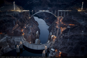
Photograph showing an aerial view of Hoover Dam, Lake Mead, the Colorado River, and the Mike O'Callaghan-Pat Tillman Memorial bridge under construction, Nevada-Arizona border, February 3, 2010
Date
Archival Collection
Description
Image
Photograph showing an aerial view of Hoover Dam, Lake Mead, the Colorado River, and the Mike O'Callaghan-Pat Tillman Memorial bridge under construction, Nevada-Arizona border, February 3, 2010
Date
Archival Collection
Description
Image
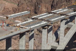
Photograph of the final tub girder brought into position for the Mike O'Callaghan-Pat Tillman Memorial Bridge, Nevada-Arizona border, April 15, 2010
Date
Archival Collection
Description
Image

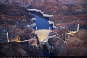
Photograph showing an aerial view of Hoover Dam, the original road between Arizona and Nevada, and the Mike O'Callaghan-Pat Tillman Memorial Bridge under construction, Nevada-Arizona border, May 22, 2009
Date
Archival Collection
Description
Image