Search the Special Collections and Archives Portal
Search Results

UNLV College of Fine Arts presents the 11th Annual Nevada Entertainer/Artist Hall of Fame: digital photographs
Date
2014-03-27
Archival Collection
Description
Photographs from the University of Nevada, Las Vegas Creative Services Records (2010s) (PH-00388-05). The UNLV College of Fine Arts presents the 11th Annual Nevada Entertainer/Artist Hall of Fame honoring artist Tim Bavington; vocalist and musician Sue Kim; and jazz vocalist Joe Williams (posthumously) during a ceremony in the Student Union Ballroom March 27, 2014 at the University of Nevada, Las Vegas Also being recognized are June Brennan, who receives the College of Fine Arts Dean's Medal, and musician (drummer for The Killers) Ronnie Vannucci, the College of Fine Arts Alumnus of the Year. Client: College of Fine Arts.
Image

Visiting professor Joshua Bonde and Professor Stephen Rowland's dig: digital photographs
Date
2014-03-20
Archival Collection
Description
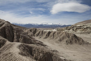
Photographs from the University of Nevada, Las Vegas Creative Services Records (2010s) (PH-00388-05). Visiting professor Joshua Bonde and Professor Stephen Rowland's dig March 19-20, 2014 took place in an area dubbed The Sump in northern end of Fish Lake Valley near Dyer, NV. Organized to retrieve a previously identified 12-16 million year-old portion of a head initially identified as an early four tusk elephant type animal, the dig was conducted over spring break. Boundary Peak and the White Mountains can be seen in the distance. Client: College of Sciences.
Image


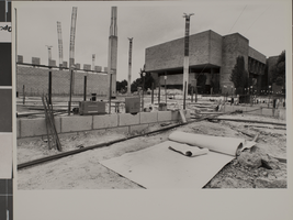
Photograph of Thomas Beam Engineering Complex, University of Nevada, Las Vegas, circa 1980s
Date
1980 to 1989
Archival Collection
Description
An exterior of the Thomas Beam Engineering Complex under construction at the University of Nevada, Las Vegas (UNLV).
Image
Audio recording clip of interview with Stephen Ronshaugen by Joan Leavitt, November 26, 2004
Date
2004-11-26
Archival Collection
Description
Narrator affiliation: Special Assistant Manager, U.S. Department of Energy
Sound
Audio recording clip of interview with Patrick Rowe by Joan Leavitt, November 5, 2004
Date
2004-11-05
Archival Collection
Description
Narrator affiliation: Drilling Engineer, Reynolds Electrical and Engineering Company (REECo)
Sound
Audio recording clip of interview with Brenda Scruton by Shannon Applegate, June 29, 2004
Date
2004-06-29
Archival Collection
Description
Narrator affiliation: Senior Employment Representative, Reynolds Electrical and Engineering Company (REECo)
Sound
Audio recording clip of interview with Frank Solaegui by Joan Leavitt, December 1, 2004
Date
2004-12-01
Archival Collection
Description
Narrator affiliation: Drilling Manager, Reynolds Electrical and Engineering Company (REECo)
Sound
Audio recording clip of interview with Anne Symens-Bucher by Suzanne Becker, August 6, 2005
Date
2005-08-06
Archival Collection
Description
Narrator affiliation: Co-Founder, Nevada Desert Experience
Sound
Audio recording clip of interview with Erik Thompson by Suzanne Becker, March 4, 2006
Date
2006-03-04
Archival Collection
Description
Narrator affiliation: Board of Trustees, Nevada Desert Experience
Sound
Pagination
Refine my results
Content Type
Creator or Contributor
Subject
Archival Collection
Digital Project
Resource Type
Year
Material Type
Place
Language
Records Classification
