Search Results
Lincoln County Archaeological Initiative Collection
Identifier
MS-01126
Abstract
The Lincoln County Archaeological Initiative Collection (2016-2019) contains digital files of oral histories collected as part of A Ranching and Farming Context for Lincoln County, Nevada, ca. 1857 to 1934 (Oliver et al. 2018). The collection consists of thirteen digital oral history recordings and corresponding transcripts, as well as a final report of phase one of the project. The entire collection is digital files.
Archival Collection
Economic Opportunity Board of Clark County (Nev.): rosters, correspondence
Date
1964 to 1970
Archival Collection
Description
From the Clark County Economic Opportunity Board Records -- Series I. Administrative. This folder contains reports, correspondence, and rosters of the Economic Opportunity Board of Clark County, Nevada from 1964 through 1970.
Text
Preservation Association of Clark County Photograph Collection
Identifier
PH-00060
Abstract
The Preservation Association of Clark County Photograph Collection consists of five black-and-white photographic prints and negatives from approximately 1980. Images depict scenes from the preservation process of the Old Las Vegas Mormon Fort as well as images of members of the Preservation Association of Clark County, University of Nevada, Las Vegas Libraries, and Nevada government officials in Las Vegas, Nevada.
Archival Collection
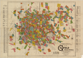
Map of U.S. patent and location surveys in the Goldfield Mining District, Esmeralda and Nye Counties, Nevada, 1907
Date
1907
Description
'Elmer J. Chute, E.M. and Olmstead & Rich. U.S. Deputy Mineral Surveyors, 1907. Copyright 1907 by Elmer J. Chute, E.M., Goldfield, Nev.' Includes index Includes township and range grid. Scale [ca. 1:22,800. 1 in. to approx. 1900 feet]
Text
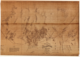
Map of the Bullfrog Mining District, Nye County, Nevada, circa 1905
Date
1901 to 1909
Description
'Compiled by Geo. E. Sherer and W.B. Milliken, miners and surveyors, Bull Frog, Nye Co., Nevada.' 'Photo. Lith. Britton & Rey, S.F.' Scale [ca. 1:16,800. 1 inch to approximately 1,400 feet]. Blueline print.
Image

Map of Lincoln County, Nevada and Mohave County, Arizona area, 1892
Date
1892
Description
'Henry Gannett, chief geographer ; A.H. Thompson, geographer in charge ; triangulation by H.M. Wilson ; topography by H.M. Wilson and Powell survey.' 'Edition of Mar. 1892, reprinted 1929.' Handwritten legend on right-side margin of map. Original publisher: Dept. of the Interior, U.S. Geological Survey. Scale 1:250,000polyconic proj. (W 115°--W 114°/N 37°--N 35°).
Image
Clark County, Nevada School District Annual Reports
Identifier
MS-00665
Abstract
The Clark County, Nevada School District Annual Reports include reports created by the Clark County School District from 1970 to 1980. Reports for the school years of 1972 to 1973, 1973 to 1974, and 1976 to 1977 are not included.
Archival Collection
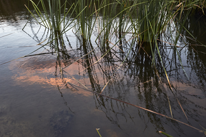
Clark County Wetlands Park, Clark County, Nevada: digital photograph
Date
2016-07-09
Archival Collection
Description
The sunset is reflected in a settling pond at the Clark County Wetlands Park.
Image

Clark County Wetlands Park, Clark County, Nevada: digital photograph
Date
2016-07-09
Archival Collection
Description
The sunset is reflected in a settling pond at the Clark County Wetlands Park.
Image